| Sgurr Innse | |
|---|---|
 Sgurr Innse | |
| Highest point | |
| Elevation | 809 m (2,654 ft)[1] |
| Prominence | 216 m (709 ft) |
| Listing | Corbett, Marilyn |
| Coordinates | 56°49′59″N 4°48′16″W / 56.8331°N 4.8044°W |
| Geography | |
| Location | Lochaber, Scotland |
| Parent range | Grampian Mountains |
| OS grid | NN290748 |
| Topo map | OS Landranger 41 |
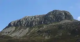
Sgurr Innse (809 m) is a mountain in the Grampian Mountains of Scotland, situated south of the village of Roybridge in Lochaber.
A rocky lump of a mountain, it offers fantastic views from its summit.[2]
References
- ↑ "Sgurr Innse". hill-bagging.co.uk. Retrieved 16 May 2019.
- ↑ "walkhighlands Sgurr Innse". walkhighlands.co.uk. Retrieved 16 May 2019.
This article is issued from Wikipedia. The text is licensed under Creative Commons - Attribution - Sharealike. Additional terms may apply for the media files.