| Site of Special Scientific Interest | |
 | |
| Location | Norfolk |
|---|---|
| Grid reference | TM 109 828[1] |
| Interest | Biological |
| Area | 10.3 hectares (25 acres)[1] |
| Notification | 1988[1] |
| Location map | Magic Map |
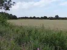
Shelfanger Meadows is a 10.3-hectare (25-acre) biological Site of Special Scientific Interest north of Diss in Norfolk.[1][2]
This site in the valley of a tributary of the River Waveney is described by Natural England as "one of the most important areas of unimproved grassland in Norfolk". It has been traditionally managed by a hay cut followed by grazing for hundreds of years, and as a result its flora is rich, including uncommon species. There are also areas where springs make the grassland marshy.[3]
The site is private land with no public access.
References
- 1 2 3 4 "Designated Sites View: Shelfanger Meadows". Sites of Special Scientific Interest. Natural England. Retrieved 22 July 2018.
- ↑ "Map of Shelfanger Meadows". Sites of Special Scientific Interest. Natural England. Retrieved 22 July 2018.
- ↑ "Shelfanger Meadows citation" (PDF). Sites of Special Scientific Interest. Natural England. Retrieved 22 July 2018.

Wikimedia Commons has media related to Shelfanger Meadows.
This article is issued from Wikipedia. The text is licensed under Creative Commons - Attribution - Sharealike. Additional terms may apply for the media files.