Simontornya | |
|---|---|
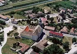 Aerial view | |
 Flag  Coat of arms | |
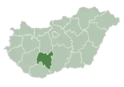
 Simontornya Location of Simontornya | |
| Coordinates: 46°45′15″N 18°32′51″E / 46.75408°N 18.54754°E | |
| Country | |
| County | Tolna |
| Area | |
| • Total | 33.83 km2 (13.06 sq mi) |
| Population (2015)[1] | |
| • Total | 4,051 |
| • Density | 120/km2 (310/sq mi) |
| Time zone | UTC+1 (CET) |
| • Summer (DST) | UTC+2 (CEST) |
| Postal code | 7081 |
| Area code | 74 |
Simontornya is a town in Tolna County, Hungary.
- Pictures of the town
 Simon's Tower at the center of town
See also
External links
Wikimedia Commons has media related to Simontornya.
- Simontornya's info page
- Street map (in Hungarian)
References
- ↑ Gazetteer of Hungary, 1st January 2015. Hungarian Central Statistical Office.
| City with county rights |
|   |
|---|---|---|
| Towns | ||
| Large villages | ||
| Villages |
| |
| Other topics |
| |
This article is issued from Wikipedia. The text is licensed under Creative Commons - Attribution - Sharealike. Additional terms may apply for the media files.