Smolné Pece | |
|---|---|
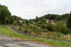 Houses in Smolné Pece | |
 Flag  Coat of arms | |
 Smolné Pece Location in the Czech Republic | |
| Coordinates: 50°17′30″N 12°45′55″E / 50.29167°N 12.76528°E | |
| Country | |
| Region | Karlovy Vary |
| District | Karlovy Vary |
| Founded | 1872 |
| Area | |
| • Total | 6.45 km2 (2.49 sq mi) |
| Elevation | 518 m (1,699 ft) |
| Population (2023-01-01)[1] | |
| • Total | 236 |
| • Density | 37/km2 (95/sq mi) |
| Time zone | UTC+1 (CET) |
| • Summer (DST) | UTC+2 (CEST) |
| Postal code | 362 25 |
| Website | www |
Smolné Pece (German: Pechöfen) is a municipality and village in Karlovy Vary District in the Karlovy Vary Region of the Czech Republic. It has about 200 inhabitants.
History
Smolné Pece was established in 1872.[2]
References
- ↑ "Population of Municipalities – 1 January 2023". Czech Statistical Office. 2023-05-23.
- ↑ "Historie obce" (in Czech). Obec Smolné Pece. Retrieved 2022-04-12.
Wikimedia Commons has media related to Smolné Pece.
This article is issued from Wikipedia. The text is licensed under Creative Commons - Attribution - Sharealike. Additional terms may apply for the media files.