Soebatsfontein | |
|---|---|
 Soebatsfontein  Soebatsfontein | |
| Coordinates: 30°07′01″S 17°34′59″E / 30.117°S 17.583°E | |
| Country | South Africa |
| Province | Northern Cape |
| District | Namakwa |
| Municipality | Kamiesberg |
| Area | |
| • Total | 0.42 km2 (0.16 sq mi) |
| Population (2011)[1] | |
| • Total | 276 |
| • Density | 660/km2 (1,700/sq mi) |
| Racial makeup (2011) | |
| • Coloured | 97.8% |
| • Indian/Asian | 0.4% |
| • White | 1.8% |
| First languages (2011) | |
| • Afrikaans | 96.4% |
| • Tswana | 1.8% |
| • Other | 1.8% |
| Time zone | UTC+2 (SAST) |
| PO box | 8257 |
Soebatsfontein is a settlement in Namakwa District Municipality in the Northern Cape province of South Africa.
Settlement 80 km south-west of Springbok and 48 km north-west of Kamieskroon. The name, Afrikaans for ‘begging or pleading fountain’, dates from an incident about 1898 in which Hendrik S(t)ievert, a farmhand, was murdered by San in spite of his begging for mercy.[2]
References
- 1 2 3 4 "Main Place Soebatsfontein". Census 2011.
- ↑ "Dictionary of Southern African Place Names (Public Domain)". Human Science Research Council. p. 409.
Municipalities and communities of Namakwa District Municipality, Northern Cape | ||
|---|---|---|
District seat: Springbok | ||
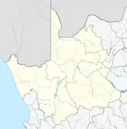
| Hantam | .svg.png.webp) Namakwa District within South Africa | |
| Kamiesberg | ||
| Karoo Hoogland | ||
| Khâi-Ma | ||
| Nama Khoi | ||
| Richtersveld | ||
This article is issued from Wikipedia. The text is licensed under Creative Commons - Attribution - Sharealike. Additional terms may apply for the media files.