Songieu | |
|---|---|
Part of Haut Valromey | |
Location of Songieu | |
 Songieu  Songieu | |
| Coordinates: 45°58′24″N 5°42′08″E / 45.9733°N 5.7022°E | |
| Country | France |
| Region | Auvergne-Rhône-Alpes |
| Department | Ain |
| Arrondissement | Belley |
| Canton | Plateau d'Hauteville |
| Commune | Haut Valromey |
| Area 1 | 20.58 km2 (7.95 sq mi) |
| Population (2019)[1] | 119 |
| • Density | 5.8/km2 (15/sq mi) |
| Time zone | UTC+01:00 (CET) |
| • Summer (DST) | UTC+02:00 (CEST) |
| Postal code | 01260 |
| Elevation | 567–1,275 m (1,860–4,183 ft) (avg. 750 m or 2,460 ft) |
| 1 French Land Register data, which excludes lakes, ponds, glaciers > 1 km2 (0.386 sq mi or 247 acres) and river estuaries. | |
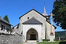
Église St Martin Songieu Haut Valromey
Songieu (French pronunciation: [sɔ̃ʒjø]) is a former commune in the Ain department in eastern France. On 1 January 2016, it was merged into the new commune Haut Valromey.[2]
Population
| Year | Pop. | ±% |
|---|---|---|
| 2005 | 120 | — |
| 2006 | 118 | −1.7% |
| 2007 | 117 | −0.8% |
| 2008 | 121 | +3.4% |
| 2009 | 126 | +4.1% |
| 2010 | 130 | +3.2% |
| 2011 | 130 | +0.0% |
| 2012 | 129 | −0.8% |
| 2013 | 129 | +0.0% |
| 2014 | 128 | −0.8% |
| 2015 | 128 | +0.0% |
See also
References
- ↑ Téléchargement du fichier d'ensemble des populations légales en 2019, INSEE
- ↑ Arrêté préfectoral 29 September 2015 (in French)
Wikimedia Commons has media related to Songieu.
This article is issued from Wikipedia. The text is licensed under Creative Commons - Attribution - Sharealike. Additional terms may apply for the media files.