South Mound, Kansas | |
|---|---|
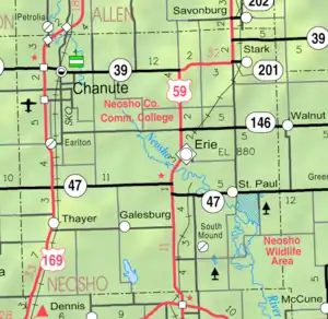 KDOT map of Neosho County (legend) | |
 South Mound  South Mound | |
| Coordinates: 37°26′14″N 95°13′43″W / 37.43722°N 95.22861°W[1] | |
| Country | United States |
| State | Kansas |
| County | Neosho |
| Elevation | 988 ft (301 m) |
| Population | |
| • Total | 27 |
| Time zone | UTC-6 (CST) |
| • Summer (DST) | UTC-5 (CDT) |
| Area code | 620 |
| FIPS code | 20-66800 [1] |
| GNIS ID | 469698 [1] |
South Mound is an unincorporated community in Neosho County, Kansas, United States.[1] As of the 2020 census, the population of the community and nearby areas was 27.[2]
History
South Mound was located on the Missouri–Kansas–Texas Railroad.[3] The railroad tracks were removed in 1989 following the M-K-T's merger with Missouri Pacific.
A post office was opened in South Mound in 1872, and remained in operation until it was discontinued in 1971.[4]
Demographics
| Census | Pop. | Note | %± |
|---|---|---|---|
| 2020 | 27 | — | |
| U.S. Decennial Census | |||
For statistical purposes, the United States Census Bureau has defined this community as a census-designated place (CDP).
References
- 1 2 3 4 5 "South Mound, Kansas", Geographic Names Information System, United States Geological Survey, United States Department of the Interior
- 1 2 "Profile of South Mound, Kansas (CDP) in 2020". United States Census Bureau. Archived from the original on June 19, 2022. Retrieved June 19, 2022.
- ↑ Duncan, L. Wallace (1902). History of Neosho and Wilson Counties, Kansas. Monitor Printing Company. p. 78.
- ↑ "Kansas Post Offices, 1828-1961 (archived)". Kansas Historical Society. Archived from the original on October 9, 2013. Retrieved June 20, 2014.
{{cite web}}: CS1 maint: unfit URL (link)
Further reading
External links
Municipalities and communities of Neosho County, Kansas, United States | ||
|---|---|---|
| Cities | 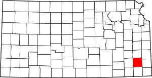 Map of Kansas highlighting Neosho County | |
| Unincorporated communities | ||
| Ghost towns | ||
| Civil townships | ||
| Footnotes | †This community is designated a Census-Designated Place (CDP) by the United States Census Bureau. ‡This community also has portions in an adjacent county or counties. | |
This article is issued from Wikipedia. The text is licensed under Creative Commons - Attribution - Sharealike. Additional terms may apply for the media files.