Srbce | |
|---|---|
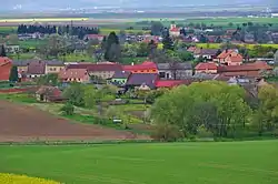 View from the east | |
.svg.png.webp) Flag .svg.png.webp) Coat of arms | |
 Srbce Location in the Czech Republic | |
| Coordinates: 49°18′8″N 17°13′45″E / 49.30222°N 17.22917°E | |
| Country | |
| Region | Olomouc |
| District | Prostějov |
| First mentioned | 1141 |
| Area | |
| • Total | 1.59 km2 (0.61 sq mi) |
| Elevation | 267 m (876 ft) |
| Population (2023-01-01)[1] | |
| • Total | 78 |
| • Density | 49/km2 (130/sq mi) |
| Time zone | UTC+1 (CET) |
| • Summer (DST) | UTC+2 (CEST) |
| Postal code | 798 27 |
| Website | www |
Srbce is a municipality and village in Prostějov District in the Olomouc Region of the Czech Republic. It has about 80 inhabitants.
Srbce lies approximately 21 kilometres (13 mi) south-east of Prostějov, 33 km (21 mi) south of Olomouc, and 221 km (137 mi) south-east of Prague.
References
Wikimedia Commons has media related to Srbce.
This article is issued from Wikipedia. The text is licensed under Creative Commons - Attribution - Sharealike. Additional terms may apply for the media files.