St. Peter, Kansas | |
|---|---|
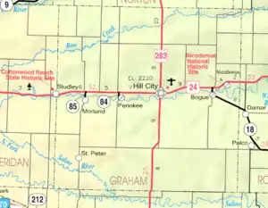 KDOT map of Graham County (legend) | |
 St. Peter  St. Peter | |
| Coordinates: 39°11′23″N 100°5′21″W / 39.18972°N 100.08917°W[1] | |
| Country | United States |
| State | Kansas |
| County | Graham |
| Elevation | 2,494 ft (760 m) |
| Time zone | UTC-6 (CST) |
| • Summer (DST) | UTC-5 (CDT) |
| Area code | 785 |
| FIPS code | 20-62525 [1] |
| GNIS ID | 471325 [1] |
St. Peter is an unincorporated community in Graham County, Kansas, United States.[1][2]
History
The community was originally named Hoganville. The post office in St. Peter, established in 1894 as Hoganville, was discontinued in 1920.[3] The population in 1910 was 50.[4]
Education
The community is served by Graham County USD 281 public school district.
References
- 1 2 3 4 5 "St. Peter, Kansas", Geographic Names Information System, United States Geological Survey, United States Department of the Interior
- ↑ "County History (archived)". Graham County, Kansas. Archived from the original on April 6, 2014. Retrieved June 10, 2014.
{{cite web}}: CS1 maint: unfit URL (link) - ↑ "Kansas Post Offices, 1828-1961 (archived)". Kansas Historical Society. Archived from the original on October 9, 2013. Retrieved June 10, 2014.
{{cite web}}: CS1 maint: unfit URL (link) - ↑ Blackmar, Frank Wilson (1912). Kansas: A Cyclopedia of State History, Volume 2. Chicago: Standard Publishing Company. p. 633.
Further reading
External links
Municipalities and communities of Graham County, Kansas, United States | ||
|---|---|---|
| Cities | 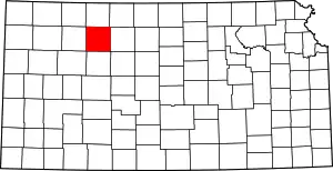 Map of Kansas highlighting Graham County | |
| Unincorporated communities | ||
| Ghost towns | ||
| Townships | ||
| Footnotes | †This community is designated a Census-Designated Place (CDP) by the United States Census Bureau. | |
This article is issued from Wikipedia. The text is licensed under Creative Commons - Attribution - Sharealike. Additional terms may apply for the media files.