Stadtschlaining | |
|---|---|
 | |
 Coat of arms | |
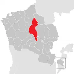 Location within Oberwart district | |
 Stadtschlaining Location within Austria | |
| Coordinates: 47°19′N 16°16′E / 47.317°N 16.267°E | |
| Country | Austria |
| State | Burgenland |
| District | Oberwart |
| Government | |
| • Mayor | Herbert Dienstl |
| Area | |
| • Total | 42.07 km2 (16.24 sq mi) |
| Elevation | 409 m (1,342 ft) |
| Population (2018-01-01)[2] | |
| • Total | 1,980 |
| • Density | 47/km2 (120/sq mi) |
| Time zone | UTC+1 (CET) |
| • Summer (DST) | UTC+2 (CEST) |
| Postal code | 7461 |
| Website | www.stadtschlaining.at |
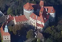
Stadtschlaining (Hungarian: Városszalónak, Város-Szalónak) is a town in the district of Oberwart in the Austrian state of Burgenland. The Burg Schlaining, built by Henry I Kőszegi, is located there, which hosts the Austrian Study Centre for Peace and Conflict Resolution (ASPR) and the Peace Museum.
Population
| Year | Pop. | ±% |
|---|---|---|
| 1869 | 3,586 | — |
| 1880 | 3,633 | +1.3% |
| 1890 | 3,675 | +1.2% |
| 1900 | 3,566 | −3.0% |
| 1910 | 3,121 | −12.5% |
| 1923 | 2,795 | −10.4% |
| 1934 | 2,695 | −3.6% |
| 1939 | 2,567 | −4.7% |
| 1951 | 2,424 | −5.6% |
| 1961 | 2,255 | −7.0% |
| 1971 | 2,273 | +0.8% |
| 1981 | 2,203 | −3.1% |
| 1991 | 2,284 | +3.7% |
| 2001 | 2,093 | −8.4% |
| 2011 | 2,064 | −1.4% |
References
- ↑ "Dauersiedlungsraum der Gemeinden Politischen Bezirke und Bundesländer - Gebietsstand 1.1.2018". Statistics Austria. Retrieved 10 March 2019.
- ↑ "Einwohnerzahl 1.1.2018 nach Gemeinden mit Status, Gebietsstand 1.1.2018". Statistics Austria. Retrieved 9 March 2019.
Gallery
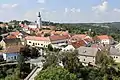 Center of Stadtschlaining
.JPG.webp) Catholic parish church
Catholic parish church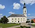 Protestant parish church
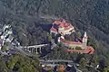
This article is issued from Wikipedia. The text is licensed under Creative Commons - Attribution - Sharealike. Additional terms may apply for the media files.