Staszów County
Powiat staszowski | |
|---|---|
 Flag 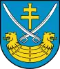 Coat of arms | |
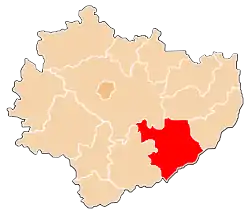 Location within the voivodeship | |
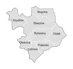 Division into gminas | |
| Coordinates (Staszów): 50°31′01.56″N 21°11′37.64″E / 50.5171000°N 21.1937889°E | |
| Country |  Poland Poland |
| Voivodeship | Świętokrzyskie |
| Seat | Staszów |
| Gminas | |
| Area (through the years 2008-2010)[1] | |
| • Total | 924.80 km2 (357.07 sq mi) |
| Population (2019) | |
| • Total | 67,331 |
| • Density | 73/km2 (190/sq mi) |
| • Urban | 24,867 |
| • Rural | 42,464 |
| Time zone | UTC+1 (CET) |
| • Summer (DST) | UTC+2 (CEST) |
| Postal code | 28-200, 28-210, 28-220, 28-221, 28-225, 28-230, 28-232 and 28-236 |
| Area code | + 48 15 or +48 41 |
| Car plates | TSZ |
| Website | http://www.staszowski.eu |
Staszów County[2] (Polish: powiat staszowski) is a unit of territorial administration and local government (powiat) in Świętokrzyskie Voivodeship, south-central Poland. It came into being on January 1, 1999, as a result of the Polish local government reforms passed in 1998. Its administrative seat and largest town is Staszów, which lies 53 kilometres (33 mi) south-east of the regional capital Kielce. The county also contains the towns of Połaniec, lying 17 km (11 mi) south-east of Staszów, and Osiek, 21 km (13 mi) east of Staszów.
The county covers an area of 924.80 square kilometres (357.1 sq mi). As of 2019 its total population is  67,331, out of which the population of Staszów is 14,762, that of Połaniec is 8,098, that of Osiek is
  2,007, and the rural population is 42,464.[3]
Demography
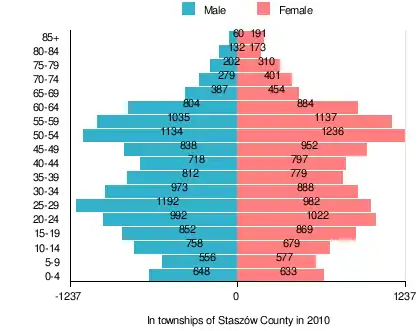
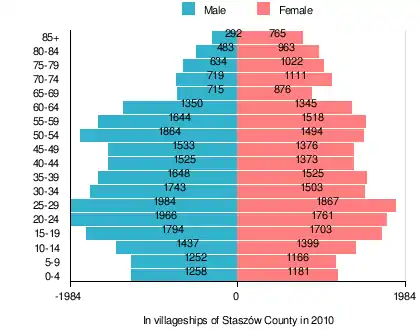
According to the 2011 Poland census, there were 73,125 people residing in Staszów County, of whom 49.5% were male and 50.5% were female (out of which the population in townships amounts to 25,336, of whom 48.8% were male and 51.2% were female; and the population of the villageships part of the county is 47,789, of whom 49.9% were male and 50.1% were female). In the county, the population was spread out, with 19.8% under the age of 18, 38.7% from 18 to 44, 24.5% from 45 to 64, and 17% who were 65 years of age or older (out of which the population in rural areas amounts to 19% under the age of 18, 39.1% from 18 to 44, 28.2% from 45 to 64, and 13.7% who were 65 years of age or older; and the population of the villageships part of the county is 20.3% under the age of 18, 38.5% from 18 to 44, 22.6% from 45 to 64, and 18.7% who were 65 years of age or older).[1]
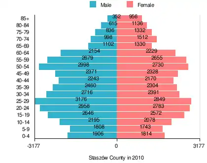
Table 1. Population level of county in 2010 — by age group[1] SPECIFICATION Measure
unitPOPULATION
(by age group in 2010)TOTAL 0-4 5-9 10-14 15-19 20-24 25-29 30-34 35-39 40-44 45-49 50-54 55-59 60-64 65-69 70-74 75-79 80-84 85 + I. TOTAL person 73,125 3,720 3,551 4,273 5,218 5,741 6,025 5,107 4,764 4,413 4,699 5,728 5,334 4,383 2,432 2,510 2,168 1,751 1,308 — of which in % 100 5.1 4.9 5.8 7.1 7.9 8.2 7 6.5 6 6.4 7.8 7.3 6 3.3 3.4 3 2.4 1.8 1. BY SEX A. Males person 36,213 1,906 1,808 2,195 2,646 2,958 3,176 2,716 2,460 2,243 2,371 2,998 2,679 2,154 1,102 998 836 615 352 — of which in % 49.5 2.6 2.5 3 3.6 4 4.3 3.7 3.4 3.1 3.2 4.1 3.7 2.9 1.5 1.4 1.1 0.8 0.5 B. Females person 36,912 1,814 1,743 2,078 2,572 2,783 2,849 2,391 2,304 2,170 2,328 2,730 2,655 2,229 1,330 1,512 1,332 1,136 956 — of which in % 50.5 2.5 2.4 2.8 3.5 3.8 3.9 3.3 3.2 3 3.2 3.7 3.6 3 1.8 2.1 1.8 1.6 1.3
Table 2. Population level of townships in 2010 — by age group[1] SPECIFICATION Measure
unitPOPULATION
(by age group in 2010)TOTAL 0-4 5-9 10-14 15-19 20-24 25-29 30-34 35-39 40-44 45-49 50-54 55-59 60-64 65-69 70-74 75-79 80-84 85 + I. TOTAL person 25,336 1,281 1,133 1,437 1,721 2,014 2,174 1,861 1,591 1,515 1,790 2,370 2,172 1,688 841 680 512 305 251 — of which in % 100 5.1 4.5 5.7 6.8 7.9 8.6 7.3 6.3 6 7.1 9.4 8.6 6.7 3.3 2.7 2 1.2 1 1. BY SEX A. Males person 12,372 648 556 758 852 992 1,192 973 812 718 838 1,134 1,035 804 387 279 202 132 60 — of which in % 48.8 2.6 2.2 3 3.4 3.9 4.7 3.8 3.2 2.8 3.3 4.5 4.1 3.2 1.5 1.1 0.8 0.5 0.2 B. Females person 12,964 633 577 679 869 1,022 982 888 779 797 952 1,236 1,137 884 454 401 310 173 191 — of which in % 51.2 2.5 2.3 2.7 3.4 4 3.9 3.5 3.1 3.1 3.8 4.9 4.5 3.5 1.8 1.6 1.2 0.7 0.8
Table 3. Population level of villageships in 2010 — by age group[1] SPECIFICATION Measure
unitPOPULATION
(by age group in 2010)TOTAL 0-4 5-9 10-14 15-19 20-24 25-29 30-34 35-39 40-44 45-49 50-54 55-59 60-64 65-69 70-74 75-79 80-84 85 + I. TOTAL person 47,789 2,439 2,418 2,836 3,497 3,727 3,851 3,246 3,173 2,898 2,909 3,358 3,162 2,695 1,591 1,830 1,656 1,446 1,057 — of which in % 100 5.1 5.1 5.9 7.3 7.8 8.1 6.8 6.6 6.1 6.1 7 6.6 5.6 3.3 3.8 3.5 3 2.2 1. BY SEX A. Males person 23,841 1,258 1,252 1,437 1,794 1,966 1,984 1,743 1,648 1,525 1,533 1,864 1,644 1,350 715 719 634 483 292 — of which in % 49.9 2.6 2.6 3 3.8 4.1 4.2 3.6 3.4 3.2 3.2 3.9 3.4 2.8 1.5 1.5 1.3 1 0.6 B. Females person 23,948 1,181 1,166 1,399 1,703 1,761 1,867 1,503 1,525 1,373 1,376 1,494 1,518 1,345 876 1,111 1,022 963 765 — of which in % 50.1 2.5 2.4 2.9 3.6 3.7 3.9 3.1 3.2 2.9 2.9 3.1 3.2 2.8 1.8 2.3 2.1 2 1.6
Table 4. Population level of county in 2010 — by sex[1] SPECIFICATION Measure
unitPOPULATION
(by sex in 2010)TOTAL Males Females I. TOTAL person 73,125 36,213 36,912 — of which in % 100 49.5 50.5 1. BY AGE GROUP A. At pre-working age person 14,509 7,439 7,070 — of which in % 19.8 10.1 9.7 B. At working age. grand total person 46,218 24,871 21,347 — of which in % 63.2 34 29.2 a. at mobile working age person 28,303 14,669 13,634 — of which in % 38.7 20.1 18.6 b. at non-mobile working age person 17,915 10,202 7,713 — of which in % 24.5 14 10.5 C. At post-working age person 12,398 3,903 8,495 — of which in % 17 5.4 11.6
Table 5. Population level of townships in 2010 — by sex[1] SPECIFICATION Measure
unitPOPULATION
(by sex in 2010)TOTAL Males Females I. TOTAL person 25,336 12,372 12,964 — of which in % 100 48.8 51.2 1. BY AGE GROUP A. At pre-working age person 4,823 2,464 2,359 — of which in % 19 9.7 9.3 B. At working age. grand total person 17,040 8,848 8,192 — of which in % 67.3 34.9 32.3 a. at mobile working age person 9,904 5,037 4,867 — of which in % 39.1 19.9 19.2 b. at non-mobile working age person 7,136 3,811 3,325 — of which in % 28.2 15.1 13.1 C. At post-working age person 3,473 1,060 2,413 — of which in % 13.7 4.2 9.5
Table 6. Population level of villageships in 2010 — by sex[1] SPECIFICATION Measure
unitPOPULATION
(by sex in 2010)TOTAL Males Females I. TOTAL person 47,789 23,841 23,948 — of which in % 100 49.9 50.1 1. BY AGE GROUP A. At pre-working age person 9,686 4,975 4,711 — of which in % 20.3 10.4 9.9 B. At working age. grand total person 29,178 16,023 13,155 — of which in % 61.1 33.5 27.5 a. at mobile working age person 18,399 9,632 8,767 — of which in % 38.5 20.2 18.3 b. at non-mobile working age person 10,779 6,391 4,388 — of which in % 22.6 13.4 9.2 C. At post-working age person 8,925 2,843 6,082 — of which in % 18.7 5.9 12.7
Neighbouring counties
Staszów County is bordered by Opatów County to the north-east, Sandomierz County and Tarnobrzeg County to the east, Mielec County and Dąbrowa County to the south, Busko County to the west, and Kielce County to the north-west.
Administrative division
The county is subdivided into eight gminas (three urban-rural and five rural). These are listed in the following table, in descending order of population.
| Gmina | Type | Area (km2) |
Population (2010) |
Seat |
| Gmina Staszów | urban-rural | 227.52 | 25,695 | Staszów |
| Gmina Połaniec | urban-rural | 75.01 | 11,814 | Połaniec |
| Gmina Bogoria | rural | 122.89 | 7,703 | Bogoria |
| Gmina Osiek | urban-rural | 129.30 | 7,744 | Osiek |
| Gmina Rytwiany | rural | 124.66 | 6,367 | Rytwiany |
| Gmina Szydłów | rural | 107.90 | 3,595 | Szydłów |
| Gmina Łubnice | rural | 84.14 | 4,116 | Łubnice |
| Gmina Oleśnica | rural | 53.38 | 2,020 | Oleśnica |
References
- 1 2 3 4 5 6 7 8 9 10 11 "Local Data Bank (Bank Danych Lokalnych) – Layout by NTS nomenclature (Układ wg klasyfikacji NTS)". demografia.stat.gov.pl: GUS. 10 March 2011.
- ↑ "Staszowski, powiat, województwo świętokrzyskie" [Staszów, county, Świętokrzyskie Province, Poland]. Topographical map prepared in 1:10,000 scale. Aerial and satellite orthophotomap (in Polish). Head Office of Geodesy and Cartography, Poland, Warsaw. 2011. geoportal.gov.pl. Retrieved 27 April 2011.
- ↑ GUS. "Population. Size and structure and vital statistics in Poland by territorial division in 2019. As of 30th June". stat.gov.pl. Retrieved 2020-09-14.
External links
| Seat | | |
|---|---|---|
| Urban-rural gminas | ||
| Rural gminas | ||
| City counties |
|  |
|---|---|---|
| Land counties | ||