 | |
|---|---|
 | |
| Route information | |
Part of  E881 E881 | |
| Length | 407 km (253 mi) |
| Major junctions | |
| North end | İğneada, Kırklareli |
| South end | Bornova, Izmir |
| Location | |
| Country | Turkey |
| Highway system | |
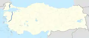
D.565 is a 407 km (253 mi) long north–south state road running south from İğneada on the Black Sea to Izmir. The route is broken into two parts by the Sea of Marmara: a 128 km (80 mi) long section in East Thrace from İğneada to Tekirdağ and a 279 km (173 mi) section in Anatolia from Bandırma to Izmir. The gap is connected by a car ferry operating between the two port cities. The route is mostly a four lane highway except for the first 61 km (38 mi) section at its northern end.[1]
In two separate sections, the D.565 runs concurrently with two other state roads in East Thrace: with the D.020 between Poyralı and Pınarhisar and with the D.100 between Lüleburgaz and Büyükkarıştıran.
Main intersections
East Thrace
| Province | District | km | mi | Destination | Notes |
|---|---|---|---|---|---|
| Kırklareli | Demirköy | 0.0 | 0.0 | P.39-01 (İğneada Rd.) — Limanköy | |
| Pınarhisar | 61 |  D.020 — Istanbul D.020 — Istanbul |
Eastern end of concurrency with D.020 | ||
| 73 | D.020 — Edirne |
Western end of concurrency with D.020 | |||
| Lüleburgaz | 96 |  O-3 — Edirne, Istanbul O-3 — Edirne, Istanbul |
Toll entrance/exit | ||
| 102 |  D.100 — Kapıkule D.100 — Kapıkule |
Western end of concurrency with D.100 | |||
| 120 | D.100 — Istanbul |
Eastern end of concurrency with D.100 | |||
| Tekirdağ | Muratlı | 132 | P.59-77 — Çeneköy | ||
| Tekirdağ | 153 |  D.110 — Silivri, İpsala D.110 — Silivri, İpsala |
Anatolia
| Province | District | km | mi | Destination | Notes |
|---|---|---|---|---|---|
| Balıkesir | Bandırma | 0.0 | 0.0 | Port of Bandırma | Carferry crosses the Sea of Marmara to D.565 in East Thrace. |
 D.200 — Çanakkale D.200 — Çanakkale |
Northern end of concurrency with D.200 | ||||
| Atatürk Cd. | |||||
| D.200 — Bursa |
Southern end of concurrency with D.200 | ||||
 P.10-03 — Manyas P.10-03 — Manyas |
|||||
| Susurluk |  D.573 — Karacabey D.573 — Karacabey |
||||
 O-5 — Gebze, Izmir O-5 — Gebze, Izmir |
Under construction (2019) | ||||
| Balıkesir | O-5 — Gebze, Izmir |
Toll entrance/exit | |||
 P.10-75 — Şamlı P.10-75 — Şamlı |
|||||
 D.230 — Edremit, Kütahya D.230 — Edremit, Kütahya |
Northern end of the Balıkesir Beltway, cloverleaf interchange | ||||
 D.555 — Sındırgı D.555 — Sındırgı |
Southern end of the Balıkesir Beltway, cloverleaf interchange | ||||
 P.10-51 — Savaştepe P.10-51 — Savaştepe |
|||||
 P.10-31 — Sındırgı P.10-31 — Sındırgı |
|||||
| Manisa | Kırkağaç | 0.0 | 0.0 | P.45-05 — Kırkağaç | |
| P.05-13 — Bakır | |||||
| Akhisar | P.45-12 — Sındırgı | ||||
 D.240 — Bergama D.240 — Bergama |
|||||
| P.45-06 — Palamut | |||||
| D.555 — Salihli |
|||||
| Saruhanlı | O-5 — Gebze, Izmir |
Toll entrance/exit | |||
| P.45-03 — Hacıveliler | |||||
| Manisa |  D.250 — Turgutlu D.250 — Turgutlu |
||||
| Mimar Sinan Blv. — Manisa | Northern end of the Manisa Beltway | ||||
| D.250 — Menemen |
|||||
| Mimar Sinan Blv. — Manisa | Southern end of the Manisa Beltway | ||||
| Izmir | Bornova | 0.0 | 0.0 |  D.300 — Çeşme, Afyon D.300 — Çeşme, Afyon |
Half Y-interchange |
References
- ↑ Türkiye Haritası (Map) (in Turkish). Karayolları Genel Müdürlüğü. Retrieved 2015-06-18.
External links
| East–west highways |  | |
|---|---|---|
| North–south highways |
| |
Main highways highlighted | ||


This article is issued from Wikipedia. The text is licensed under Creative Commons - Attribution - Sharealike. Additional terms may apply for the media files.