Sturgeon Lake 154B | |
|---|---|
| Sturgeon Lake Indian Reserve No. 154B | |
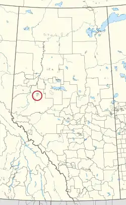 Location in Alberta | |
| First Nation | Sturgeon Lake Cree |
| Treaty | 8 |
| Country | Canada |
| Province | Alberta |
| Municipal district | Greenview |
| Area | |
| • Total | 97.1 ha (239.9 acres) |
Sturgeon Lake 154B is an Indian reserve of the Sturgeon Lake Cree Nation in Alberta, located within the Municipal District of Greenview No. 16.[2] It is 4 kilometres south of Sturgeon Lake.[1]
References
- 1 2 "Reserve/Settlement/Village Detail". Crown–Indigenous Relations and Northern Affairs Canada. Government of Canada. 14 November 2008. Retrieved August 12, 2019.
- ↑ Government of Alberta (May 25, 2019). Municipal Boundaries (Map). AltaLIS.
| Ethnolinguistic groups (by language family) | |||||||||||||||||||||||||||||
|---|---|---|---|---|---|---|---|---|---|---|---|---|---|---|---|---|---|---|---|---|---|---|---|---|---|---|---|---|---|
| Historical polities | |||||||||||||||||||||||||||||
| Numbered Treaties | |||||||||||||||||||||||||||||
| Tribal councils and band governments |
| ||||||||||||||||||||||||||||

.svg.png.webp)

54°58′54″N 117°33′39″W / 54.9817°N 117.5607°W
This article is issued from Wikipedia. The text is licensed under Creative Commons - Attribution - Sharealike. Additional terms may apply for the media files.