Swamp Angel, Kansas | |
|---|---|
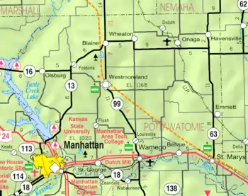 KDOT map of Pottawatomie County (legend) | |
 Swamp Angel  Swamp Angel | |
| Coordinates: 39°11′40″N 96°28′56″W / 39.19444°N 96.48222°W[1] | |
| Country | United States |
| State | Kansas |
| County | Pottawatomie |
| Named for | Swamp Angel |
| Elevation | 1,001 ft (305 m) |
| Time zone | UTC-6 (CST) |
| • Summer (DST) | UTC-5 (CDT) |
| Area code | 785 |
| FIPS code | 20-69600 |
| GNIS ID | 484778 [1] |
Swamp Angel is an unincorporated community in Pottawatomie County, Kansas, United States.[1] It is located approximately halfway between Manhattan and St. George.
History
It was likely named after the Swamp Angel, a large Parrott rifle used in the American Civil War.[2]
Education
The community is served by Manhattan–Ogden USD 383 public school district.
References
- 1 2 3 4 U.S. Geological Survey Geographic Names Information System: Swamp Angel, Kansas
- ↑ "Swamp Angel, Pottawatomie County". Lost Kansas Communities. Retrieved June 22, 2014.
Further reading
External links
Municipalities and communities of Pottawatomie County, Kansas, United States | ||
|---|---|---|
| Cities | 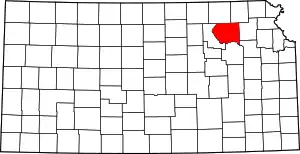 Map of Kansas highlighting Pottawatomie County | |
| Unincorporated communities | ||
| Footnotes | ‡This community also has portions in an adjacent county or counties. | |
This article is issued from Wikipedia. The text is licensed under Creative Commons - Attribution - Sharealike. Additional terms may apply for the media files.