Taciba | |
|---|---|
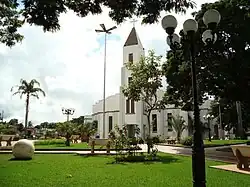 Central square | |
 Flag  Coat of arms | |
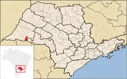 Location in São Paulo state | |
 Taciba Location in Brazil | |
| Coordinates: 22°23′23″S 51°17′5″W / 22.38972°S 51.28472°W | |
| Country | Brazil |
| Region | Southeast |
| State | São Paulo |
| Mesoregion | Presidente Prudente |
| Microregion | Presidente Prudente |
| Government | |
| • Mayor | Alair Antônio Batista (PV) |
| • Deputy Mayor | Edson Roberto Batista |
| Area | |
| • Total | 607 km2 (234 sq mi) |
| Population (2020 [1]) | |
| • Total | 6,329 |
| • Density | 10/km2 (27/sq mi) |
| Time zone | UTC−3 (BRT) |
| Postal code | 19590-000 |
| Website | http://www.taciba.sp.gov.br/ |
Taciba is a municipality in the state of São Paulo in Brazil. The population is 6,329 (2020 est.) in an area of 607 km².[2] The elevation is 416 m.
References
This article is issued from Wikipedia. The text is licensed under Creative Commons - Attribution - Sharealike. Additional terms may apply for the media files.