Tada-U Township | |
|---|---|
 | |
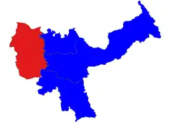 Location in Kyaukse district | |
 Tada-U Township | |
| Coordinates: 21°49′08″N 95°58′25″E / 21.81889°N 95.97361°E | |
| Country | Myanmar (Burma) |
| Region | Mandalay Region |
| District | Kyaukse District |
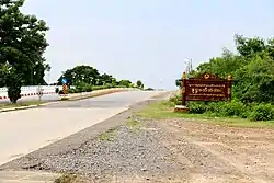
| Capital | Tada-U |
| Government | |
| • Type | Township Municipal |
| • NLD | Thiha Aung |
| Area | |
| • Total | 140.54 sq mi (363.99 km2) |
| Elevation | 200 ft (60 m) |
| Population (2014) | |
| • Total | 138,617 |
| • Density | 990/sq mi (380/km2) |
| Time zone | UTC+6:30 (MMT) |
Tada-U Township is a township of Kyaukse District in the Mandalay Region of Myanmar (Burma).
Tada-U Township's urban area is sub-divided into 3 wards; while Tada-U Township's rural area is sub-divided into 61 village-tracts, which are further sub-divided into 164 villages.
Village tracts
- Gwaykone
- Hta Naung Kaing
- Zee Kang
- Thabyegan
- Taungbyone
- Kangyi
- Thaman
- Thedaw
- Gaungkwe
- Myaengu
- Chaungkwa
- Myinthe
- Pyukan
- Hantharwaddy
- Zaygyo
- Zaga-in
- Zaga-te
- Zaba twin
- Aung Thar
- Myinsaing
References
Capital: Mandalay | ||
| Kyaukse District |  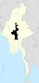 | |
| Mandalay District | ||
| Meiktila District | ||
| Myingyan District | ||
| Nyaung-U District | ||
| Pyinoolwin District | ||
| Yamethin District | ||
| Main cities and towns | ||
This article is issued from Wikipedia. The text is licensed under Creative Commons - Attribution - Sharealike. Additional terms may apply for the media files.