Tegernheim | |
|---|---|
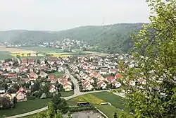 Tegernheim seen from Donaustauf Castle | |
 Coat of arms | |
Location of Tegernheim within Regensburg district 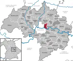 | |
 Tegernheim  Tegernheim | |
| Coordinates: 49°01′29″N 12°10′21″E / 49.02472°N 12.17250°E | |
| Country | Germany |
| State | Bavaria |
| Admin. region | Oberpfalz |
| District | Regensburg |
| Government | |
| • Mayor (2020–26) | Max Kollmannsberger[1] (FW) |
| Area | |
| • Total | 11.43 km2 (4.41 sq mi) |
| Elevation | 332 m (1,089 ft) |
| Population (2022-12-31)[2] | |
| • Total | 5,750 |
| • Density | 500/km2 (1,300/sq mi) |
| Time zone | UTC+01:00 (CET) |
| • Summer (DST) | UTC+02:00 (CEST) |
| Postal codes | 93105 |
| Dialling codes | 09403 |
| Vehicle registration | R |
| Website | www.tegernheim.de |
Tegernheim is a municipality in the district of Regensburg in Bavaria in Germany. The Danube flows through the cadastrial area of the village.
References
- ↑ Liste der ersten Bürgermeister/Oberbürgermeister in kreisangehörigen Gemeinden, Bayerisches Landesamt für Statistik, 15 July 2021.
- ↑ Genesis Online-Datenbank des Bayerischen Landesamtes für Statistik Tabelle 12411-003r Fortschreibung des Bevölkerungsstandes: Gemeinden, Stichtag (Einwohnerzahlen auf Grundlage des Zensus 2011)
This article is issued from Wikipedia. The text is licensed under Creative Commons - Attribution - Sharealike. Additional terms may apply for the media files.