Teluk Sengat | |
|---|---|
| Other transcription(s) | |
| • Jawi | تلوق سڠت |
| • Chinese | 南亚港 |
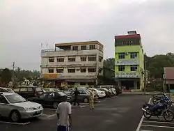 View of the business buildings in Teluk Sengat | |
| Coordinates: 13°50′S 171°45′W / 13.833°S 171.750°W | |
| Country | |
| State | |
| District | Kota Tinggi |
| Founded | 1650s |
| Became capital | 1959 |
| Area | |
| • Urban | 20 sq mi (60 km2) |
| Elevation | 3 ft (1 m) |
| Population (2001) | |
| • Urban | 58,800 |
| • Urban density | 2,534.48/sq mi (978.57/km2) |
| Time zone | UTC−11 (SST) |
| • Summer (DST) | UTC−10 (HST[2]) |
Teluk Sengat is a small town in Kota Tinggi District, Johor, Malaysia.[3] The main economic activity in this town is fishing. There are also palm oil estate nearby and a remote village named Kampung Guntong Nanas.
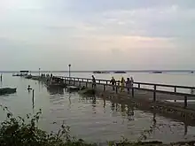
Jetty in Teluk Sengat
References
- ↑ "Weather Underground: Apia, Samoa".
- ↑ "Samoa Starts Daylight Saving Time in 2009". timeanddate.com. 2008-11-28. Retrieved 2009-08-03.
- ↑ "Latar Belakang". 20 October 2015.
| |||||||||||||||
| General topics |
|  | |||||||||||||
| Administrative divisions |
| ||||||||||||||
| City councils (Majlis Bandaraya) |
| ||||||||||||||
| Municipal councils (Majlis Perbandaran) |
| ||||||||||||||
| District councils (Majlis Daerah) |
| ||||||||||||||
| |||||||||||||||
This article is issued from Wikipedia. The text is licensed under Creative Commons - Attribution - Sharealike. Additional terms may apply for the media files.