Temnitztal | |
|---|---|
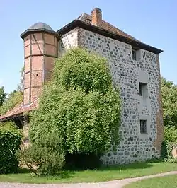 Medieval Tower | |
Location of Temnitztal within Ostprignitz-Ruppin district 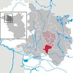 | |
 Temnitztal  Temnitztal | |
| Coordinates: 52°52′39″N 12°37′50″E / 52.87750°N 12.63056°E | |
| Country | Germany |
| State | Brandenburg |
| District | Ostprignitz-Ruppin |
| Municipal assoc. | Temnitz |
| Subdivisions | 6 Ortsteile |
| Government | |
| • Mayor (2019–24) | Michael Mann[1] |
| Area | |
| • Total | 51.95 km2 (20.06 sq mi) |
| Elevation | 38 m (125 ft) |
| Population (2021-12-31)[2] | |
| • Total | 1,525 |
| • Density | 29/km2 (76/sq mi) |
| Time zone | UTC+01:00 (CET) |
| • Summer (DST) | UTC+02:00 (CEST) |
| Postal codes | 16845 |
| Dialling codes | 033928 |
| Vehicle registration | OPR |
| Website | www.amt-temnitz.de |
Temnitztal is a municipality in the Ostprignitz-Ruppin district, in Brandenburg, Germany.
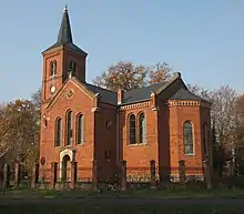
Church in Vichel
Demography
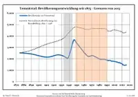
Development of population since 1875 within the current boundaries (Blue line: Population; Dotted line: Comparison to population development of Brandenburg state; Grey background: Time of Nazi rule; Red background: Time of communist rule)
|
|
References
- ↑ Landkreis Ostprignitz-Ruppin Wahl der Bürgermeisterin / des Bürgermeisters, accessed 2 July 2021.
- ↑ "Bevölkerungsentwicklung und Flächen der kreisfreien Städte, Landkreise und Gemeinden im Land Brandenburg 2021" (PDF). Amt für Statistik Berlin-Brandenburg (in German). June 2022.
- ↑ Detailed data sources are to be found in the Wikimedia Commons.Population Projection Brandenburg at Wikimedia Commons
Towns and municipalities in Ostprignitz-Ruppin | ||
|---|---|---|
Coat of Arms of Ostprignitz-Ruppin district | ||
This article is issued from Wikipedia. The text is licensed under Creative Commons - Attribution - Sharealike. Additional terms may apply for the media files.