Tepelenë District | |
|---|---|
 | |
| Coordinates: 40°20′N 19°57′E / 40.333°N 19.950°E | |
| Country | |
| Dissolved | 2000 |
| Seat | Tepelenë |
| Area | |
| • Total | 817 km2 (315 sq mi) |
| Population (2001) | |
| • Total | 32,465 |
| • Density | 40/km2 (100/sq mi) |
| Time zone | UTC+1 (CET) |
| • Summer (DST) | UTC+2 (CEST) |
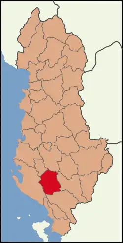
Tepelenë District (Albanian: Rrethi i Tepelenës) was one of the 36 districts of Albania, which were dissolved in July 2000 and replaced by 12 newly created counties. It had a population of 32,465 in 2001, and an area of 817 km2 (315 sq mi).[1] It was in the south of Albania, and its capital was the city of Tepelenë. Its territory is now part of Gjirokastër County: the municipalities of Tepelenë and Memaliaj.
History
At the Vjosa (Greek:Aoos) Narrows ("Aoi Stena") in the district, a Macedonian army barred the way to Epirus and, in 198 BC, a decisive battle, the Battle of the Aous, took place between a Roman army commanded by Consul Titus Quinctius Flamininus and the Macedonians commanded by Philip V. After an attempt of a truce and an inconclusive battle, a shepherd led the Roman army to a point where the Macedonians could be attacked and the Romans won the battle.
Administrative divisions
The district consisted of the following municipalities:
References
- ↑ Districts of Albania, statoids.com
External links
- Information about Tepelenë District (in Albanian)
Districts in Albania were geographic divisions made up of cities, towns and villages. They were abolished in 2000. | |
| (36) | |