Vaja | |
|---|---|
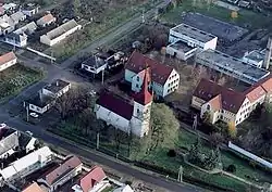 Aerial view | |
 Flag  Coat of arms | |
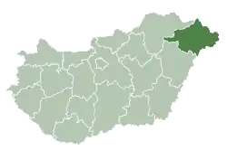
 Vaja Location of Vaja in Hungary | |
| Coordinates: 47°59′58″N 22°10′16″E / 47.9994°N 22.1711°E | |
| Country | Hungary |
| Region | Northern Great Plain |
| County | Szabolcs-Szatmár-Bereg |
| Area | |
| • Total | 28.61 km2 (11.05 sq mi) |
| Population (2015)[1] | |
| • Total | 3,515 |
| • Density | 120/km2 (320/sq mi) |
| Time zone | UTC+1 (CET) |
| • Summer (DST) | UTC+2 (CEST) |
| Postal code | 4562 |
| Area code | +36 44 |
| Website | http://vaja.hu/ |
Vaja is a town in Szabolcs-Szatmár-Bereg county, in the Northern Great Plain region of eastern Hungary.
Geography
It covers an area of 28.61 km2 (11 sq mi) and has a population of 3515 people (2015).[1]
References
- 1 2 3 Gazetteer of Hungary, 1st January 2015. Hungarian Central Statistical Office.

This article is issued from Wikipedia. The text is licensed under Creative Commons - Attribution - Sharealike. Additional terms may apply for the media files.