Valongo do Vouga | |
|---|---|
 Valongo do Vouga Location in Portugal | |
| Coordinates: 40°37′44″N 8°26′20″W / 40.629°N 8.439°W | |
| Country | |
| Region | Centro |
| Intermunic. comm. | Região de Aveiro |
| District | Aveiro |
| Municipality | Águeda |
| Area | |
| • Total | 43.20 km2 (16.68 sq mi) |
| Population (2011) | |
| • Total | 4,877 |
| • Density | 110/km2 (290/sq mi) |
| Time zone | UTC±00:00 (WET) |
| • Summer (DST) | UTC+01:00 (WEST) |
| Website | www |
Valongo do Vouga is a freguesia in Águeda Municipality, Aveiro District, Portugal.[1] The population in 2011 was 4,877,[2] in an area of 43.20 km2.[3]
Geography
Places
- Aguieira
- Aldeia
- Arrancada do Vouga
- Brunhido
- Cadaveira
- Carvalhal da Portela
- Carvalhosa
- Cavadas da Baixo
- Cavadinhas
- Espinheiros
- Fermentões
- Gândara
- Lanheses
- Lavagadas
- Moutedo
- Outeiro
- Paço
- Picadas
- Póvoa do Espírito Santo
- Quintã
- Redonda
- Sabugal
- Salgueiro
- Sobreiro
- Toural
- Val Covo
- Veiga
- Valongo
Demography
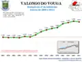 Population from 1864 to 2011
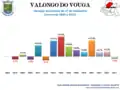 Population variation from 1864 to 2011
Elections
As of 31 December 2011, it had 4,461 registered voters.
References
- ↑ "Valongo do Vouga". cm-agueda.pt (in Portuguese). Câmara Municipal de Águeda. Retrieved 2 February 2014.
- ↑ Instituto Nacional de Estatística
- ↑ "Áreas das freguesias, concelhos, distritos e país". Retrieved 2018-11-05.
External links
- Official website (in Portuguese)
This article is issued from Wikipedia. The text is licensed under Creative Commons - Attribution - Sharealike. Additional terms may apply for the media files.