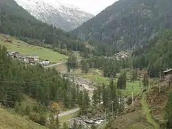
Valsavarenche
Ouahèntse | |
|---|---|
| Comune di Valsavarenche Commune de Valsavarenche | |
 | |
.svg.png.webp) Coat of arms | |
Location of Valsavarenche | |
 Valsavarenche Location of Valsavarenche in Italy 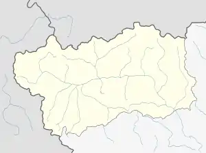 Valsavarenche Valsavarenche (Aosta Valley) | |
| Coordinates: 45°35′32″N 7°12′28″E / 45.59222°N 7.20778°E | |
| Country | Italy |
| Region | Aosta Valley |
| Province | none |
| Frazioni | Bois-de-Clin, Le Loup, Terre, Créton, Dégioz (chef-lieu), Eaux-Rousses, Fénille, Bien, Breuil, Maisonnasse, Pessey, Pont, Rovenaud, Tignet |
| Government | |
| • Mayor | Tamara Lonato - Commissario prefettizio |
| Area | |
| • Total | 139 km2 (54 sq mi) |
| Elevation | 1,000 - 4,061 m (−12,323 ft) |
| Population (31 December 2022)[2] | |
| • Total | 161 |
| • Density | 1.2/km2 (3.0/sq mi) |
| Demonym | Valsavareins |
| Time zone | UTC+1 (CET) |
| • Summer (DST) | UTC+2 (CEST) |
| Postal code | 11010 |
| Dialing code | 0165 |
| Patron saint | Our Lady of Mount Carmel |
| Saint day | 16 July |
| Website | Official website |
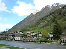
Rovenaud village
Valsavarenche (local Valdôtain: Ouahèntse; known as Valsavara under fascist rule from 1939 to 1946, and as Valsavaranche from 1946 to 1976) is a comune in the Aosta Valley, northern Italy. It is part of the Unité des communes valdôtaines du Grand-Paradis.
See also
References
- ↑ "Superficie di Comuni Province e Regioni italiane al 9 ottobre 2011". Italian National Institute of Statistics. Retrieved 16 March 2019.
- ↑ Demographics data from ISTAT

This article is issued from Wikipedia. The text is licensed under Creative Commons - Attribution - Sharealike. Additional terms may apply for the media files.