Varto District | |
|---|---|
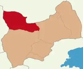 Map showing Varto District in Muş Province | |
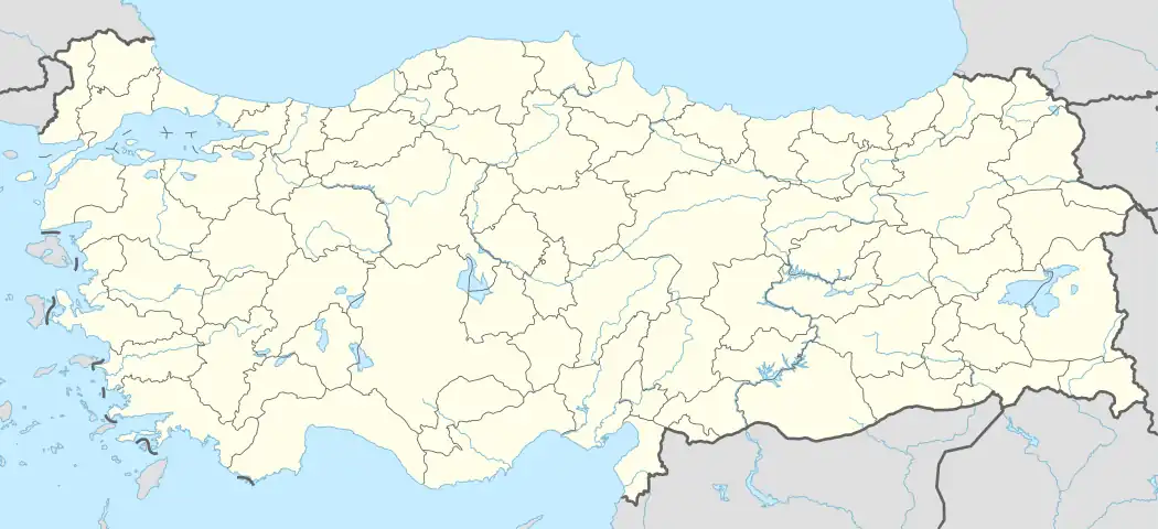 Varto District Location in Turkey | |
| Coordinates: 39°10′N 41°27′E / 39.167°N 41.450°E | |
| Country | Turkey |
| Province | Muş |
| Seat | Varto |
| Government | |
| • Kaymakam | Musa AYYILDIZ |
| Area | 1,318 km2 (509 sq mi) |
| Population (2022) | 30,267 |
| • Density | 23/km2 (59/sq mi) |
| Time zone | TRT (UTC+3) |
| Website | www |
Varto District (Armenian: Վարդոյի գաւառակ) is a district of the Muş Province of Turkey. Its seat is the town of Varto.[1] Its area is 1,318 km2,[2] and its population is 30,267 (2022).[3]
Geology and geomorphology
Varto District is surrounded by Bingöl Mountains from the north and Şerafettin Mountains from the south.[4] Akdoğan Lakes are located in the east of the district center.[5] The altitude exceeds 3000 meters in the Bingöl mountains in the north of the district center and 2300 meters in the Akdoğan and Şerafettin Mountains.[6]
Education
Hamurpet Secondary School is one of the schools in the district.[7]
Composition
There is one municipality in Varto District:[1]
There are 93 villages in Varto District:[8]
- Acarkent
- Ağaçaltı
- Ağaçkorur
- Akçatepe
- Alabalık
- Alnıaçık
- Armutkaşı
- Aşağıalagöz
- Aşağıhacıbey
- Bağiçi
- Baltaş
- Başkent
- Beşikkaya
- Boyalı
- Boylu
- Buzlugöze
- Çalıdere
- Çaltılı
- Çayçatı
- Çayıryolu
- Çaylar
- Çayönü
- Çobandağı
- Dağcılar
- Dallıöz
- Değerli
- Derince
- Diktepeler
- Doğanca
- Dönertaş
- Durucabulak
- Dutözü
- Erdoğan
- Eryurdu
- Esenler
- Gelintaşı
- Göltepe
- Gölyayla
- Görgü
- Güzeldere
- Güzelkent
- Haksever
- Hüseyinoğlu
- İçmeler
- İlbey
- Kalecik
- Karaköy
- Karameşe
- Karapınar
- Kartaldere
- Kayadelen
- Kayalıdere
- Kayalık
- Kayalıkale
- Kaygıntaş
- Kaynarca
- Koçyatağı
- Kolan
- Köprücük
- Küçüktepe
- Kumlukıyı
- Kuşluk
- Leylek
- Ocaklı
- Oğlakçı
- Ölçekli
- Omcalı
- Onpınar
- Özenç
- Özkonak
- Sağlıcak
- Sanlıca
- Sazlıca
- Seki
- Taşçı
- Taşdibek
- Taşlıyayla
- Teknedüzü
- Tepeköy
- Tuzlu
- Üçbulak
- Ulusırt
- Ünaldı
- Yarlısu
- Yayıklı
- Yayla
- Yedikavak
- Yeşildal
- Yeşilpınar
- Yılanlı
- Yukarıhacıbey
- Yurttutan
- Zorabat
References
- 1 2 İlçe Belediyesi, Turkey Civil Administration Departments Inventory. Retrieved 22 May 2023.
- ↑ "İl ve İlçe Yüz ölçümleri". General Directorate of Mapping. Retrieved 22 May 2023.
- ↑ "Address-based population registration system (ADNKS) results dated 31 December 2022, Favorite Reports" (XLS). TÜİK. Retrieved 22 May 2023.
- ↑ "Determination Of Tectonic Activity In The Varto Basin (Muş) With Geomorphic Indices" (PDF) (in Turkish). Bingöl University. March 2019. p. 1.
- ↑ "Göller". mus.ktb.gov.tr. Muş İl Kültür ve Turizm Müdürlüğü. p. 1.
- ↑ "Muş Varto ilçesinin jeotermal potansiyelinin tespiti, termal otel ve sağlık merkezi fizibilite raporu" (PDF) (in Turkish). Doğu Anadolu kalınma ajansı. 2020. p. 28.
- ↑ "Hamurpet İmam Hatip Ortaokulu". hamurpetimamhatiportaokulu.meb.k12.tr (in Turkish). Retrieved 2020-06-10.
- ↑ Köy, Turkey Civil Administration Departments Inventory. Retrieved 22 May 2023.
Varto District in Muş Province of Turkey | |||||||||||||||||||||||||||
|---|---|---|---|---|---|---|---|---|---|---|---|---|---|---|---|---|---|---|---|---|---|---|---|---|---|---|---|
| Districts | 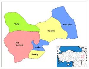 Districts of Muş | ||||||||||||||||||||||||||
| |||||||||||||||||||||||||||
Metropolitan municipalities are bolded. | |||||||||||||||||||||||||||
| Municipalities | |
|---|---|
| Villages |
|
This article is issued from Wikipedia. The text is licensed under Creative Commons - Attribution - Sharealike. Additional terms may apply for the media files.