Vered Yeriho | |
|---|---|
 | |
  Vered Yeriho | |
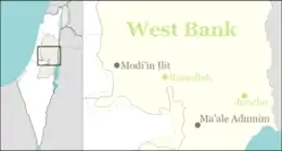
| Coordinates: 31°49′35″N 35°25′54″E / 31.82639°N 35.43167°E | |
| District | Judea and Samaria Area |
| Council | Megilot |
| Region | West Bank |
| Affiliation | Agricultural Union |
| Founded | 1979 |
| Population (2021)[1] | 364 |
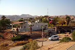
Vered Yeriho (Hebrew: וֶרֶד יְרִיחוֹ, lit. 'Rose of Jericho') is an Israeli settlement organized as a moshav in the West Bank. Located near Jericho in the Jordan Valley, it falls under the jurisdiction of Megilot Regional Council. In 2021 it had a population of 364.[1]
The international community considers Israeli settlements in the West Bank illegal under international law, but the Israeli government disputes this.[2]
History
According to ARIJ, in 1978 Israel confiscated 618 dunams of land from the Palestinian site of Nabi Musa in order to construct Vered Yeriho.[3]
The community was founded in 1979 as a result of the dissociation of the secular nucleus from the religious nucleus in Mitzpe Yeriho, a nearby settlement to the west of Vered Yeriho. The moshav is located on a hill overlooking the Aqabat Jaber section of Jericho. From the scenic perimeter road of the moshav, one can see Jericho and the northern Dead Sea.
References
- 1 2 "Regional Statistics". Israel Central Bureau of Statistics. Retrieved 22 February 2023.
- ↑ "The Geneva Convention". BBC News. 10 December 2009. Retrieved 27 November 2010.
- ↑ An Nabi Musa Locality Profile, ARIJ, p. 7