| Vidourle | |
|---|---|
 | |
  | |
| Location | |
| Country | France |
| Region | Occitanie |
| Physical characteristics | |
| Source | |
| • location | Cévennes |
| Mouth | |
• location | Mediterranean Sea |
• coordinates | 43°32′8″N 4°8′3″E / 43.53556°N 4.13417°E |
| Length | 95.0 km (59.0 mi) |
| Basin size | 1,335 km2 (515 sq mi) |
| Discharge | |
| • average | 20 m3/s (710 cu ft/s) |
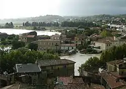
The Vidourle (French pronunciation: [viduʁl]; Vidorle in occitan) is a 95.0 km (59.0 mi) river in southern France that flows into the Mediterranean Sea in Le Grau-du-Roi.[1] Its source is in the Cévennes mountains, northwest of Saint-Hippolyte-du-Fort, at Saint-Roman-de-Codières. It flows generally southeast. At Gallargues-le-Montueux, it was crossed by the old Roman road Via Domitia with the now ruined Roman bridge Pont Ambroix.
The Vidourle flows through the following departments and towns:
References
Wikimedia Commons has media related to Vidourle.
This article is issued from Wikipedia. The text is licensed under Creative Commons - Attribution - Sharealike. Additional terms may apply for the media files.