Whitesboro, Alabama | |
|---|---|
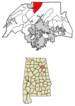 Location of Whitesboro in Etowah County, Alabama. | |
 Whitesboro | |
| Coordinates: 34°09′48″N 86°04′10″W / 34.16333°N 86.06944°W | |
| Country | United States |
| State | Alabama |
| County | Etowah |
| Area | |
| • Total | 17.50 sq mi (45.32 km2) |
| • Land | 17.48 sq mi (45.27 km2) |
| • Water | 0.02 sq mi (0.06 km2) |
| Elevation | 1,043 ft (318 m) |
| Population (2020) | |
| • Total | 2,113 |
| • Density | 120.89/sq mi (46.68/km2) |
| Time zone | UTC-6 (Central (CST)) |
| • Summer (DST) | UTC-5 (CDT) |
| Area code(s) | 256 & 938 |
| GNIS feature ID | 2582708[2] |
Whitesboro is a census-designated place and unincorporated community in Etowah County, Alabama, United States. Its population was 2,138 as of the 2010 census.[3]
Demographics
| Census | Pop. | Note | %± |
|---|---|---|---|
| 2020 | 2,113 | — | |
| U.S. Decennial Census[4] | |||
References
- ↑ "2020 U.S. Gazetteer Files". United States Census Bureau. Retrieved October 29, 2021.
- 1 2 U.S. Geological Survey Geographic Names Information System: Whitesboro, Alabama
- ↑ "U.S. Census website". United States Census Bureau. Retrieved May 14, 2011.
- ↑ "Census of Population and Housing". Census.gov. Retrieved June 4, 2016.
Municipalities and communities of Etowah County, Alabama, United States | ||
|---|---|---|
| Cities | 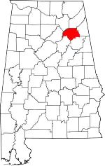 Map of Alabama highlighting Etowah County | |
| Towns | ||
| CDPs | ||
| Unincorporated communities | ||
| Former City | ||
| Footnotes | ‡This populated place also has portions in an adjacent county or counties | |
This article is issued from Wikipedia. The text is licensed under Creative Commons - Attribution - Sharealike. Additional terms may apply for the media files.