Willacoochee, Georgia | |
|---|---|
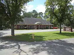 Willacoochee City Hall and Police Department | |
| Motto: Where good people live | |
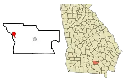 Location in Atkinson County and the state of Georgia | |
| Coordinates: 31°20′7″N 83°2′47″W / 31.33528°N 83.04639°W | |
| Country | United States |
| State | Georgia |
| County | Atkinson |
| Incorporated | November 12, 1889 |
| Area | |
| • Total | 3.82 sq mi (9.90 km2) |
| • Land | 3.82 sq mi (9.89 km2) |
| • Water | 0.00 sq mi (0.00 km2) |
| Elevation | 240 ft (73 m) |
| Population (2020) | |
| • Total | 1,240 |
| • Density | 324.61/sq mi (125.33/km2) |
| Time zone | UTC-5 (Eastern (EST)) |
| • Summer (DST) | UTC-4 (EDT) |
| ZIP code | 31650 |
| Area code | 912 |
| FIPS code | 13-82972[2] |
| GNIS feature ID | 0333429[3] |
| Website | www |
Willacoochee is a city in Atkinson County, Georgia, United States, along the Alapaha River. The population was 1,240 in 2020.[4]
History
The Georgia General Assembly incorporated Willacoochee as a town in 1889.[5] Willacoochee is a name derived from the Creek language meaning "home of the wildcats".[6]
Geography
Willacoochee is located at 31°20′7″N 83°2′47″W / 31.33528°N 83.04639°W (31.335175, -83.046381), within the Southeast Georgia region.[7] According to the U.S. Census Bureau, the city has a total area of 3.8 square miles (9.9 km2), all land.[8]
Demographics
| Census | Pop. | Note | %± |
|---|---|---|---|
| 1890 | 398 | — | |
| 1900 | 471 | 18.3% | |
| 1910 | 960 | 103.8% | |
| 1920 | 1,211 | 26.1% | |
| 1930 | 1,006 | −16.9% | |
| 1940 | 903 | −10.2% | |
| 1950 | 987 | 9.3% | |
| 1960 | 1,061 | 7.5% | |
| 1970 | 1,120 | 5.6% | |
| 1980 | 1,166 | 4.1% | |
| 1990 | 1,205 | 3.3% | |
| 2000 | 1,434 | 19.0% | |
| 2010 | 1,391 | −3.0% | |
| 2020 | 1,240 | −10.9% | |
| U.S. Decennial Census[9] | |||
| Race | Num. | Perc. |
|---|---|---|
| White (non-Hispanic) | 500 | 40.32% |
| Black or African American (non-Hispanic) | 423 | 34.11% |
| Native American | 5 | 0.4% |
| Pacific Islander | 2 | 0.16% |
| Other/Mixed | 28 | 2.26% |
| Hispanic or Latino | 282 | 22.74% |
As of the 2020 United States census, there were 1,240 people, 529 households, and 291 families residing in the city,[4] down from 2010's 1,391.[8] Among its population in 2020, 40.32% were non-Hispanic white, 34.11% Black or African American, 0.4% Native American, 0.16% Pacific Islander, 2.26% multiracial, and 22.74% Hispanic or Latino of any race.
Gallery
 A Lockheed T-33 in Willacoochee. A T-33 crashed here ca. 1960s. Located 31°20'28.7"N 83°02'52.1"W(31.341306,-83.047806)
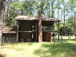 McCranie's Turpentine Still, just west of Willacoochee, on the National Register of Historic Places
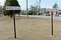 Signs indicating drainage divide
References
- ↑ "2020 U.S. Gazetteer Files". United States Census Bureau. Retrieved December 18, 2021.
- ↑ "U.S. Census website". United States Census Bureau. Retrieved January 31, 2008.
- ↑ "US Board on Geographic Names". United States Geological Survey. October 25, 2007. Retrieved January 31, 2008.
- 1 2 3 "Explore Census Data". data.census.gov. Retrieved December 14, 2021.
- ↑ Acts Passed by the General Assembly of Georgia. J. Johnston. 1889. p. 1006.
- ↑ Nestor, Sandy (May 7, 2015). Indian Placenames in America. McFarland. p. 50. ISBN 978-0-7864-9339-5.
- ↑ "US Gazetteer files: 2010, 2000, and 1990". United States Census Bureau. February 12, 2011. Retrieved April 23, 2011.
- 1 2 "Geographic Identifiers: 2010 Demographic Profile Data (G001): Willacoochee city, Georgia". U.S. Census Bureau, American Factfinder. Archived from the original on February 12, 2020. Retrieved May 6, 2013.
- ↑ "Census of Population and Housing". Census.gov. Retrieved June 4, 2015.
External links
Municipalities and communities of Atkinson County, Georgia, United States | ||
|---|---|---|
| Cities | 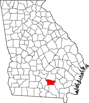 Map of Georgia highlighting Atkinson County | |
| CDP | ||
| Other unincorporated community | ||