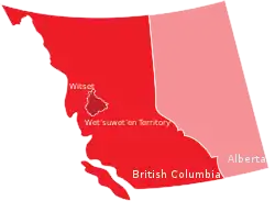
 Witset First Nation within traditional Wetʼsuwetʼen territory | |
| People | Wetʼsuwetʼen |
|---|---|
| Headquarters | 205 Beaver Road, Smithers, British Columbia V0J 2N1 |
| Province | British Columbia |
| Land | |
| Main reserve | Moricetown 1 |
| Other reserve(s) |
|
| Land area | 14.27 km2 |
| Population (2020) | |
| On reserve | 655 |
| On other land | 69 |
| Off reserve | 1331 |
| Total population | 2055 |
| Government | |
| Chief | Sandra George |
| Council |
|
| Website | |
| https://witset.ca/ | |
The Witset First Nation is a First Nations band government of the Wet'suwet'en people of Witset, British Columbia, Canada. Their mailing address is in Smithers but their main community is at Witset.[1]
Indian reserves
Indian reserves governed by the band are:[2]
- Babine Indian Reserve No. 17, between Moricetown IR No. 1 and Coryatsqua IR No. 2, south of the Moricetown CNR station, 64.80 ha.
- Babine Indian Reserve No. 18, on Corya Creek, one mile west of the Moricetown CNR station, 259 ha.
- Bulkley River Indian Reserve No. 19, on the left bank of the Bulkley River north of and adjoining Moricetown IR No. 1, 242.80 ha.
- Coryatsaqua (Moricetown) Indian Reserve No. 2, on the Smithers-Hazelton Road, the Moricetown CNR station is on this reserve, 126.40 ha.
- Jean Baptiste Indian Reserve No. 28, about 6 miles southeasterly from the Smithers CNR station, 129.50 ha.
- Moricetown Indian Reserve No. 1, on the Bulkley River 28 miles southeasterly from Hazelton, 539.50 ha.
- Oschawwinna Indian Reserve No. 3, on the Bulkley River Road, about 3 miles southeasterly from Moricetown IR No. 1, 65.0 ha.
References
External links
This article is issued from Wikipedia. The text is licensed under Creative Commons - Attribution - Sharealike. Additional terms may apply for the media files.