Xun County
浚县 | |
|---|---|
 | |
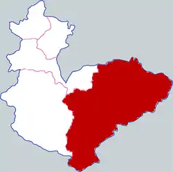 Xun County in Hebi | |
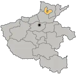 Hebi in Henan | |
| Country | People's Republic of China |
| Province | Henan |
| Prefecture-level city | Hebi |
| Area | |
| • Total | 1,088 km2 (420 sq mi) |
| Population (2019)[2] | |
| • Total | 680,700 |
| • Density | 630/km2 (1,600/sq mi) |
| Time zone | UTC+8 (China Standard) |
| Postal code | 456250 |
| Website | www |
Xun County or Xunxian (simplified Chinese: 浚县; traditional Chinese: 濬縣; pinyin: Xùn Xiàn) is a county in the north of Henan province, China. It is under the administration of the prefecture-level city of Hebi and located on the transition of the East China Plain and the Taihang Mountains.[3]
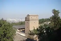
Xun County has a historic center originating to 1331, one of the best preserved of the East China Plain, and is located along the Grand Canal.[4][5][6]
The landscape is characterized by the hills of Dayao and Fuqiu rising from the plains.[6]
The Yellow River historically had its course through the south of the county, causing numerous floods.[3]
History
During the Shang dynasty the area was called Li (黎). During the Western Han Dynasty it was first established as a county. In 1115 it was named Xunzhou, governing over Liyang County and Wei County. It was demoted to a county named Xun County in 1369.[6][7][3]
Administrative divisions
As 2012, this county is divided to 7 towns and 2 townships.[8]
- Towns
|
- Townships
- Baisi Township (白寺乡)
- Wangzhuang Township (王庄乡)
Climate
| Climate data for Xunxian (2007–2020 normals, extremes 1981–2010) | |||||||||||||
|---|---|---|---|---|---|---|---|---|---|---|---|---|---|
| Month | Jan | Feb | Mar | Apr | May | Jun | Jul | Aug | Sep | Oct | Nov | Dec | Year |
| Record high °C (°F) | 17.6 (63.7) |
24.6 (76.3) |
27.4 (81.3) |
34.9 (94.8) |
38.0 (100.4) |
41.4 (106.5) |
41.9 (107.4) |
38.0 (100.4) |
37.4 (99.3) |
34.4 (93.9) |
27.4 (81.3) |
22.3 (72.1) |
41.9 (107.4) |
| Mean daily maximum °C (°F) | 4.5 (40.1) |
8.5 (47.3) |
15.5 (59.9) |
21.1 (70.0) |
27.0 (80.6) |
32.5 (90.5) |
32.3 (90.1) |
30.6 (87.1) |
26.9 (80.4) |
21.6 (70.9) |
13.0 (55.4) |
6.8 (44.2) |
20.0 (68.0) |
| Daily mean °C (°F) | −1.1 (30.0) |
2.6 (36.7) |
9.3 (48.7) |
14.9 (58.8) |
21.2 (70.2) |
26.2 (79.2) |
27.3 (81.1) |
25.7 (78.3) |
21.0 (69.8) |
15.5 (59.9) |
7.5 (45.5) |
0.9 (33.6) |
14.3 (57.7) |
| Mean daily minimum °C (°F) | −5.7 (21.7) |
−2.4 (27.7) |
3.6 (38.5) |
8.9 (48.0) |
15.2 (59.4) |
20.2 (68.4) |
23.0 (73.4) |
21.7 (71.1) |
16.2 (61.2) |
10.7 (51.3) |
2.9 (37.2) |
−3.9 (25.0) |
9.2 (48.6) |
| Record low °C (°F) | −17.5 (0.5) |
−14.8 (5.4) |
−8.0 (17.6) |
−1.1 (30.0) |
5.0 (41.0) |
12.0 (53.6) |
17.1 (62.8) |
12.3 (54.1) |
6.8 (44.2) |
−1.4 (29.5) |
−15.1 (4.8) |
−15.4 (4.3) |
−17.5 (0.5) |
| Average precipitation mm (inches) | 6.0 (0.24) |
9.3 (0.37) |
14.8 (0.58) |
33.2 (1.31) |
50.6 (1.99) |
66.2 (2.61) |
146.1 (5.75) |
110.2 (4.34) |
60.9 (2.40) |
29.4 (1.16) |
22.5 (0.89) |
5.6 (0.22) |
554.8 (21.86) |
| Average precipitation days (≥ 0.1 mm) | 2.9 | 3.3 | 3.5 | 5.1 | 6.1 | 7.5 | 10.8 | 9.3 | 7.0 | 5.7 | 4.7 | 2.6 | 68.5 |
| Average snowy days | 3.1 | 2.9 | 1.2 | 0.2 | 0 | 0 | 0 | 0 | 0 | 0 | 1.2 | 2.5 | 11.1 |
| Average relative humidity (%) | 62 | 59 | 59 | 64 | 66 | 62 | 77 | 82 | 76 | 68 | 69 | 65 | 67 |
| Mean monthly sunshine hours | 107.5 | 125.5 | 173.7 | 200.6 | 219.8 | 198.9 | 165.5 | 176.0 | 156.3 | 151.0 | 129.1 | 121.7 | 1,925.6 |
| Percent possible sunshine | 34 | 40 | 47 | 51 | 50 | 46 | 37 | 43 | 43 | 44 | 42 | 40 | 43 |
| Source: China Meteorological Administration[9][10] | |||||||||||||
Notable people
Transport
References
- ↑ 最新人口信息 www.hongheiku.com (in Chinese). hongheiku. Retrieved 2021-01-12.
- ↑ 最新人口信息 www.hongheiku.com (in Chinese). hongheiku. Retrieved 2021-01-12.
- 1 2 3 "浚县(濬縣) - Google Search". www.google.com. Retrieved 2021-05-19.
- ↑ 王曉飛. "河南濬縣:因運河而興 打造千年"大運河文化帶"-新華網". m.xinhuanet.com. Retrieved 2021-05-19.
- ↑ 馬金章 (2012-06-01). 流經濬縣的大運河 (in Chinese). Beijing Book Co. Inc. ISBN 978-7-5348-3835-4.
- 1 2 3 4 "濬縣概況". www.xunxian.gov.cn. Retrieved 2021-05-19.
- ↑ 中國縣情大全: 華東卷 [Encyclopedia of Chinese Counties: East China Volume] (in Chinese). 中國社會出版社. 1992.
- ↑ 鹤壁市-行政区划网 www.xzqh.org (in Chinese). XZQH. Retrieved 2012-05-24.
- ↑ 中国气象数据网 – WeatherBk Data (in Simplified Chinese). China Meteorological Administration. Retrieved 12 August 2023.
- ↑ 中国气象数据网 (in Simplified Chinese). China Meteorological Administration. Retrieved 12 August 2023.
35°40′34″N 114°33′00″E / 35.67611°N 114.55000°E