| Yaya | |
|---|---|
 | |
| Location | |
| Country | Russia |
| Physical characteristics | |
| Mouth | Chulym |
• coordinates | 56°58′02″N 86°22′18″E / 56.9672°N 86.3717°E |
| Length | 380 km (240 mi) |
| Basin size | 11,700 km2 (4,500 sq mi) |
| Basin features | |
| Progression | Chulym→ Ob→ Kara Sea |
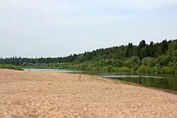
The Yaya (Russian: Яя) is a river in Siberian Russia, a left tributary of the Chulym, that flows through Kemerovo and Tomsk oblasts. It is 380 kilometres (240 mi) long, and has a drainage basin of 11,700 square kilometres (4,500 sq mi).[1] It originates in Kuznetsk Alatau. The urban-type settlement of Yaya is situated on this river.
References
- ↑ "Река ЯЯ in the State Water Register of Russia". textual.ru (in Russian).
This article is issued from Wikipedia. The text is licensed under Creative Commons - Attribution - Sharealike. Additional terms may apply for the media files.