Zerba | |
|---|---|
| Comune di Zerba | |
.jpg.webp) | |
 Coat of arms | |
Location of Zerba | |
 Zerba Location of Zerba in Italy 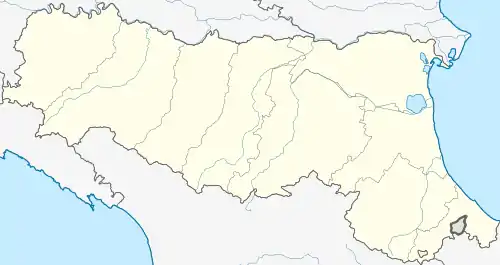 Zerba Zerba (Emilia-Romagna) | |
| Coordinates: 44°40′N 9°17′E / 44.667°N 9.283°E | |
| Country | Italy |
| Region | Emilia-Romagna |
| Province | Province of Piacenza (PC) |
| Area | |
| • Total | 25.0 km2 (9.7 sq mi) |
| Population (Dec. 2004)[2] | |
| • Total | 123 |
| • Density | 4.9/km2 (13/sq mi) |
| Time zone | UTC+1 (CET) |
| • Summer (DST) | UTC+2 (CEST) |
| Postal code | 29020 |
| Dialing code | 0523 |
Zerba (Piacentino: Ṡèrba) is a comune (municipality) in the Province of Piacenza in the Italian region Emilia-Romagna, located about 170 kilometres (110 mi) west of Bologna and about 50 kilometres (31 mi) southwest of Piacenza. As of 31 December 2004, it had a population of 123 and an area of 25.0 square kilometres (9.7 sq mi).[3]
Zerba borders the following municipalities: Brallo di Pregola, Cabella Ligure, Cerignale, Fabbrica Curone, Ottone, Santa Margherita di Staffora.
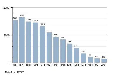
Demographic evolution
References
- ↑ "Superficie di Comuni Province e Regioni italiane al 9 ottobre 2011". Italian National Institute of Statistics. Retrieved 16 March 2019.
- ↑ "Popolazione Residente al 1° Gennaio 2018". Italian National Institute of Statistics. Retrieved 16 March 2019.
- ↑ All demographics and other statistics: Italian statistical institute Istat.

This article is issued from Wikipedia. The text is licensed under Creative Commons - Attribution - Sharealike. Additional terms may apply for the media files.