Zolling | |
|---|---|
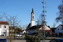 Market square with the Church of Saint John the Baptist and maypole | |
 Coat of arms | |
Location of Zolling within Freising district 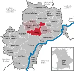 | |
 Zolling  Zolling | |
| Coordinates: 48°27′N 11°46′E / 48.450°N 11.767°E | |
| Country | Germany |
| State | Bavaria |
| Admin. region | Oberbayern |
| District | Freising |
| Municipal assoc. | Zolling |
| Government | |
| • Mayor (2020–26) | Helmut Priller[1] |
| Area | |
| • Total | 34.59 km2 (13.36 sq mi) |
| Elevation | 429 m (1,407 ft) |
| Population (2022-12-31)[2] | |
| • Total | 5,051 |
| • Density | 150/km2 (380/sq mi) |
| Time zone | UTC+01:00 (CET) |
| • Summer (DST) | UTC+02:00 (CEST) |
| Postal codes | 85406 |
| Dialling codes | 08167 |
| Vehicle registration | FS |
| Website | www.zolling.de |
Zolling is a municipality in the Bavarian district of Freising. Associated villages are: Anglberg, Flitzing, Thann, Palzing, Oberappersdorf, and Appersdorf.
Zolling lies 6 km to the north of Freising.
Gallery
 Zolling power plant
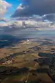 Bird's eye view of Zolling with its power plant
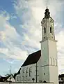 St. John's church in Zolling
References
- ↑ Liste der ersten Bürgermeister/Oberbürgermeister in kreisangehörigen Gemeinden, Bayerisches Landesamt für Statistik, 15 July 2021.
- ↑ Genesis Online-Datenbank des Bayerischen Landesamtes für Statistik Tabelle 12411-003r Fortschreibung des Bevölkerungsstandes: Gemeinden, Stichtag (Einwohnerzahlen auf Grundlage des Zensus 2011)
Towns and municipalities in Freising (district) | ||
|---|---|---|
Coat of Arms of Freising district | ||
This article is issued from Wikipedia. The text is licensed under Creative Commons - Attribution - Sharealike. Additional terms may apply for the media files.