Antanandrenitelo | |
|---|---|
Village | |
.jpg.webp) | |
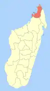
 Antanandrenitelo Location in Madagascar | |
| Coordinates: 12°40′10″S 49°17′36″E / 12.66944°S 49.29333°E | |
| Country | |
| Region | Diana |
| District | Antsiranana II |
| Elevation | 300 m (1,000 ft) |
| Population (2001) | |
| • Total | unknown |
| Time zone | UTC3 (EAT) |
Antanandrenitelo is a town in Madagascar. It belongs to the district of Antsiranana II, which is a part of Diana Region.
Geography
Antanandrenitelo is situated at the Route Nationale 6 between Mahavanona and Sadjoavato.
Sights
The Tsingy Rouge are situated near this town.
References and notes
- ↑ Estimated based on DEM data from Shuttle Radar Topography Mission
| Ambanja (24) - 203 |
|  |
|---|---|---|
| Ambilobe (15) - 204 | ||
| Antsiranana (Diego Suarez) (1) - 201 | ||
| Antsiranana II (22) - 202 |
| |
| Nosy Be (5) - 207 |
| |
5 districts; 51 communes | ||
12°35′55″S 49°22′45″E / 12.59861°S 49.37917°E
This article is issued from Wikipedia. The text is licensed under Creative Commons - Attribution - Sharealike. Additional terms may apply for the media files.