Arifat | |
|---|---|
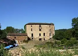 The chateau in Arifat | |
 Coat of arms | |
Location of Arifat | |
 Arifat  Arifat | |
| Coordinates: 43°47′07″N 2°21′53″E / 43.7853°N 2.3647°E | |
| Country | France |
| Region | Occitania |
| Department | Tarn |
| Arrondissement | Castres |
| Canton | Le Haut Dadou |
| Intercommunality | CC Centre Tarn |
| Government | |
| • Mayor (2020–2026) | Sylvian Cals[1] |
| Area 1 | 20.28 km2 (7.83 sq mi) |
| Population | 139 |
| • Density | 6.9/km2 (18/sq mi) |
| Time zone | UTC+01:00 (CET) |
| • Summer (DST) | UTC+02:00 (CEST) |
| INSEE/Postal code | 81017 /81360 |
| Elevation | 267–583 m (876–1,913 ft) (avg. 430 m or 1,410 ft) |
| 1 French Land Register data, which excludes lakes, ponds, glaciers > 1 km2 (0.386 sq mi or 247 acres) and river estuaries. | |
Arifat (French pronunciation: [aʁifa]; Occitan: Arifat) is a commune of the Tarn department in southern France.
The inhabitants are known as Arifatois.
Geography
The commune is traversed by the river Dadou.
Demographics
| Year | Pop. | ±% p.a. |
|---|---|---|
| 1968 | 215 | — |
| 1975 | 195 | −1.39% |
| 1982 | 201 | +0.43% |
| 1990 | 171 | −2.00% |
| 1999 | 158 | −0.87% |
| 2007 | 162 | +0.31% |
| 2012 | 148 | −1.79% |
| 2017 | 164 | +2.07% |
| Source: INSEE[3] | ||
Places of interest
- Arifat's castle
- Waterfall
See also
References
- ↑ "Répertoire national des élus: les maires". data.gouv.fr, Plateforme ouverte des données publiques françaises (in French). 2 December 2020.
- ↑ "Populations légales 2021". The National Institute of Statistics and Economic Studies. 28 December 2023.
- ↑ Population en historique depuis 1968, INSEE
Wikimedia Commons has media related to Arifat.
This article is issued from Wikipedia. The text is licensed under Creative Commons - Attribution - Sharealike. Additional terms may apply for the media files.