Bälau | |
|---|---|
 Flag  Coat of arms | |
Location of Bälau within Herzogtum Lauenburg district 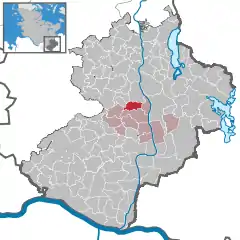 | |
 Bälau 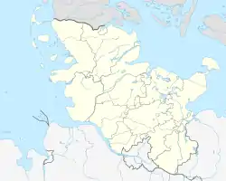 Bälau | |
| Coordinates: 53°37′N 10°37′E / 53.617°N 10.617°E | |
| Country | Germany |
| State | Schleswig-Holstein |
| District | Herzogtum Lauenburg |
| Municipal assoc. | Breitenfelde |
| Government | |
| • Mayor | Hans Schmaljohann |
| Area | |
| • Total | 6.50 km2 (2.51 sq mi) |
| Elevation | 36 m (118 ft) |
| Population (2022-12-31)[1] | |
| • Total | 222 |
| • Density | 34/km2 (88/sq mi) |
| Time zone | UTC+01:00 (CET) |
| • Summer (DST) | UTC+02:00 (CEST) |
| Postal codes | 23881 |
| Dialling codes | 04542 |
| Vehicle registration | RZ |
| Website | www |
Bälau is a municipality in the Breitenfelde collective municipality (Amt) located in the Lauenburg district (Kreis) in southeastern Schleswig-Holstein, Germany.
Bälau covers 6.50 square kilometers (1600 acres) which are mostly used for agriculture, with a relatively high proportion of forest. In addition to agricultural businesses, the village has a riding school and vacation apartments. It is a peaceful village, without a major road running through it, and a village green bordered by lime trees. Several well-preserved farmer's houses set the character for the village.
References
This article is issued from Wikipedia. The text is licensed under Creative Commons - Attribution - Sharealike. Additional terms may apply for the media files.