Bach | |
|---|---|
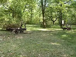 Phosphate mine railway wagons | |
Location of Bach | |
 Bach  Bach | |
| Coordinates: 44°21′05″N 1°40′20″E / 44.3514°N 1.6722°E | |
| Country | France |
| Region | Occitania |
| Department | Lot |
| Arrondissement | Cahors |
| Canton | Marches du Sud-Quercy |
| Intercommunality | Pays de Lalbenque-Limogne |
| Government | |
| • Mayor (2020–2026) | Patrick Valette[1] |
| Area 1 | 21.02 km2 (8.12 sq mi) |
| Population | 196 |
| • Density | 9.3/km2 (24/sq mi) |
| Time zone | UTC+01:00 (CET) |
| • Summer (DST) | UTC+02:00 (CEST) |
| INSEE/Postal code | 46013 /46230 |
| Elevation | 220–337 m (722–1,106 ft) |
| 1 French Land Register data, which excludes lakes, ponds, glaciers > 1 km2 (0.386 sq mi or 247 acres) and river estuaries. | |
Bach is a commune in the Lot department in southwestern France.
The phosphate mines of Cloup d'Aural (French: Phosphatière du Cloup d'Aural) are located here.
Population
| Year | Pop. | ±% p.a. |
|---|---|---|
| 1968 | 144 | — |
| 1975 | 127 | −1.78% |
| 1982 | 124 | −0.34% |
| 1990 | 140 | +1.53% |
| 1999 | 144 | +0.31% |
| 2007 | 171 | +2.17% |
| 2012 | 165 | −0.71% |
| 2017 | 178 | +1.53% |
| Source: INSEE[3] | ||
See also
References
- ↑ "Répertoire national des élus: les maires". data.gouv.fr, Plateforme ouverte des données publiques françaises (in French). 2 December 2020.
- ↑ "Populations légales 2021". The National Institute of Statistics and Economic Studies. 28 December 2023.
- ↑ Population en historique depuis 1968, INSEE
Wikimedia Commons has media related to Bach (Lot).
This article is issued from Wikipedia. The text is licensed under Creative Commons - Attribution - Sharealike. Additional terms may apply for the media files.