Benetússer | |
|---|---|
 | |
 Flag  Coat of arms | |
 Benetússer Location in Spain | |
| Coordinates: 39°25′30″N 0°23′46″W / 39.42500°N 0.39611°W | |
| Country | |
| Autonomous community | |
| Province | Valencia |
| Comarca | Horta Sud |
| Judicial district | Catarroja |
| Government | |
| • Alcalde | sergio pastor(2007) (PSPV/PSOE) |
| Area | |
| • Total | 0.76 km2 (0.29 sq mi) |
| Elevation | 11 m (36 ft) |
| Population (2018)[1] | |
| • Total | 14,668 |
| • Density | 19,000/km2 (50,000/sq mi) |
| Demonym(s) | Benetussí, benetussina |
| Time zone | UTC+1 (CET) |
| • Summer (DST) | UTC+2 (CEST) |
| Postal code | 46910 |
| Official language(s) | Valencian |
| Website | Official website |
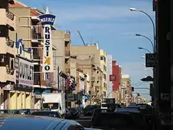
Benetússer (Valencian: [beneˈtuseɾ]; Spanish: Benetúser) is a municipality in the comarca of Horta Sud in the Valencian Community, Spain. At the 2001 census the municipality had a population of 13,425 inhabitants and a land area of only 0.78 km² (0.301 sq mi). Its population density of 17,211.5 persons/km² was the third highest in Spain (after Mislata and L'Hospitalet de Llobregat).
References
- ↑ Municipal Register of Spain 2018. National Statistics Institute.
External links
Wikimedia Commons has media related to Benetússer.
- Ajuntament de Benetússer Official website (in Spanish) (Valencian)
Municipalities of Horta Sud | ||
|---|---|---|

This article is issued from Wikipedia. The text is licensed under Creative Commons - Attribution - Sharealike. Additional terms may apply for the media files.