Blaison-Saint-Sulpice | |
|---|---|
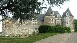 The Château of Blaison | |
Location of Blaison-Saint-Sulpice | |
 Blaison-Saint-Sulpice 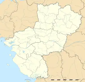 Blaison-Saint-Sulpice | |
| Coordinates: 47°24′00″N 0°22′16″W / 47.400°N 0.371°W | |
| Country | France |
| Region | Pays de la Loire |
| Department | Maine-et-Loire |
| Arrondissement | Angers |
| Canton | Les Ponts-de-Cé |
| Government | |
| • Mayor (2020–2026) | Jean-Claude Legendre[1] |
| Area 1 | 24.35 km2 (9.40 sq mi) |
| Population | 1,302 |
| • Density | 53/km2 (140/sq mi) |
| Time zone | UTC+01:00 (CET) |
| • Summer (DST) | UTC+02:00 (CEST) |
| INSEE/Postal code | 49029 /49320 |
| 1 French Land Register data, which excludes lakes, ponds, glaciers > 1 km2 (0.386 sq mi or 247 acres) and river estuaries. | |
Blaison-Saint-Sulpice (French pronunciation: [blɛzɔ̃ sɛ̃ sylpis] ⓘ) is a commune in the Maine-et-Loire department of western France. The municipality was established on 1 January 2016 and consists of the former communes of Blaison-Gohier and Saint-Sulpice.[3]
See also
References
Wikimedia Commons has media related to Blaison-Saint-Sulpice.
- ↑ "Répertoire national des élus: les maires" (in French). data.gouv.fr, Plateforme ouverte des données publiques françaises. 13 September 2022.
- ↑ "Populations légales 2021". The National Institute of Statistics and Economic Studies. 28 December 2023.
- ↑ Arrêté préfectoral 23 November 2015 (in French)
This article is issued from Wikipedia. The text is licensed under Creative Commons - Attribution - Sharealike. Additional terms may apply for the media files.