Canton Bend, Alabama | |
|---|---|
 Canton Bend, Alabama Location within the state of Alabama  Canton Bend, Alabama Canton Bend, Alabama (the United States) | |
| Coordinates: 32°03′12″N 87°20′56″W / 32.05347°N 87.34888°W | |
| Country | United States |
| State | Alabama |
| County | Wilcox |
| Elevation | 213 ft (65 m) |
| Time zone | UTC-6 (Central (CST)) |
| • Summer (DST) | UTC-5 (CDT) |
| Area code | 334 |
Canton Bend, once known simply as Canton, is an unincorporated community in Wilcox County, Alabama, United States.[1] Located on the south bank of the Alabama River, it served as the first county seat for Wilcox County from 1819 until its move to Camden in 1833.[2] It has several historic sites, including Youpon Plantation and the Tristram Bethea House.[3]
Geography
Canton Bend is located at 32°03′12″N 87°20′56″W / 32.05347°N 87.34888°W and has an elevation of 213 feet (65 m).[1]
References
- 1 2 U.S. Geological Survey Geographic Names Information System: Canton Bend, Alabama
- ↑ "History of Wilcox County, Alabama". Wilcox Area Chamber of Commerce. Wilcox Area Chamber of Commerce. Archived from the original on March 10, 2011. Retrieved April 3, 2011.
- ↑ "National Register Information System". National Register of Historic Places. National Park Service. April 15, 2008.
Municipalities and communities of Wilcox County, Alabama, United States | ||
|---|---|---|
| City | 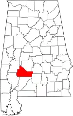 Map of Alabama highlighting Wilcox County | |
| Towns | ||
| CDPs | ||
| Unincorporated communities | ||
| Ghost towns | ||
This article is issued from Wikipedia. The text is licensed under Creative Commons - Attribution - Sharealike. Additional terms may apply for the media files.