Chodská Lhota | |
|---|---|
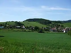 View from the southeast | |
 Flag  Coat of arms | |
 Chodská Lhota Location in the Czech Republic | |
| Coordinates: 49°21′30″N 13°5′0″E / 49.35833°N 13.08333°E | |
| Country | |
| Region | Plzeň |
| District | Domažlice |
| First mentioned | 1325 |
| Area | |
| • Total | 10.28 km2 (3.97 sq mi) |
| Elevation | 500 m (1,600 ft) |
| Population (2023-01-01)[1] | |
| • Total | 406 |
| • Density | 39/km2 (100/sq mi) |
| Time zone | UTC+1 (CET) |
| • Summer (DST) | UTC+2 (CEST) |
| Postal code | 345 10 |
| Website | www |
Chodská Lhota (until 1946 Lhota u Kdyně; German: Melhut) is a municipality and village in Domažlice District in the Plzeň Region of the Czech Republic. It has about 400 inhabitants.
Chodská Lhota lies approximately 16 kilometres (10 mi) south-east of Domažlice, 50 km (31 mi) south-west of Plzeň, and 127 km (79 mi) south-west of Prague.
Gallery
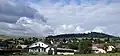 General view
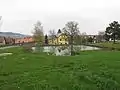 Water tank
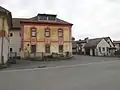 Pub
Pub
References
Wikimedia Commons has media related to Chodská Lhota.
This article is issued from Wikipedia. The text is licensed under Creative Commons - Attribution - Sharealike. Additional terms may apply for the media files.