Křenovy | |
|---|---|
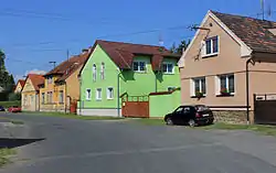 Centre of Křenovy | |
 Flag  Coat of arms | |
 Křenovy Location in the Czech Republic | |
| Coordinates: 49°32′21″N 13°1′18″E / 49.53917°N 13.02167°E | |
| Country | |
| Region | Plzeň |
| District | Domažlice |
| First mentioned | 1379 |
| Area | |
| • Total | 3.13 km2 (1.21 sq mi) |
| Elevation | 368 m (1,207 ft) |
| Population (2023-01-01)[1] | |
| • Total | 144 |
| • Density | 46/km2 (120/sq mi) |
| Time zone | UTC+1 (CET) |
| • Summer (DST) | UTC+2 (CEST) |
| Postal code | 345 61 |
| Website | www |
Křenovy is a municipality and village in Domažlice District in the Plzeň Region of the Czech Republic. It has about 100 inhabitants.
Křenovy lies approximately 13 kilometres (8 mi) north-east of Domažlice, 35 km (22 mi) south-west of Plzeň, and 118 km (73 mi) south-west of Prague.
History
The first written mention of Křenovy is from 1379.[2]
References
- ↑ "Population of Municipalities – 1 January 2023". Czech Statistical Office. 2023-05-23.
- ↑ "Historie" (in Czech). Obec Křenovy. Retrieved 2022-07-09.
Wikimedia Commons has media related to Křenovy.
This article is issued from Wikipedia. The text is licensed under Creative Commons - Attribution - Sharealike. Additional terms may apply for the media files.