Codolet | |
|---|---|
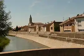 A general view of Codolet | |
.svg.png.webp) Coat of arms | |
Location of Codolet | |
 Codolet  Codolet | |
| Coordinates: 44°07′37″N 4°42′10″E / 44.1269°N 4.7028°E | |
| Country | France |
| Region | Occitania |
| Department | Gard |
| Arrondissement | Nîmes |
| Canton | Roquemaure |
| Intercommunality | CA Gard Rhodanien |
| Government | |
| • Mayor (2020–2026) | Sébastien Bayart[1] |
| Area 1 | 5.17 km2 (2.00 sq mi) |
| Population | 604 |
| • Density | 120/km2 (300/sq mi) |
| Time zone | UTC+01:00 (CET) |
| • Summer (DST) | UTC+02:00 (CEST) |
| INSEE/Postal code | 30084 /30200 |
| Elevation | 27–50 m (89–164 ft) (avg. 34 m or 112 ft) |
| 1 French Land Register data, which excludes lakes, ponds, glaciers > 1 km2 (0.386 sq mi or 247 acres) and river estuaries. | |
Codolet (French pronunciation: [kɔdɔlɛ]) is a commune in the Gard department in southern France.
Population
| Year | Pop. | ±% |
|---|---|---|
| 1962 | 381 | — |
| 1968 | 393 | +3.1% |
| 1975 | 386 | −1.8% |
| 1982 | 433 | +12.2% |
| 1990 | 458 | +5.8% |
| 1999 | 558 | +21.8% |
| 2008 | 691 | +23.8% |
See also
References
- ↑ "Répertoire national des élus: les maires" (in French). data.gouv.fr, Plateforme ouverte des données publiques françaises. 13 September 2022.
- ↑ "Populations légales 2021". The National Institute of Statistics and Economic Studies. 28 December 2023.
External links
Wikimedia Commons has media related to Codolet.
- Official site (in French)
This article is issued from Wikipedia. The text is licensed under Creative Commons - Attribution - Sharealike. Additional terms may apply for the media files.