Crest, Missouri | |
|---|---|
 Crest  Crest | |
| Coordinates: 38°27′01″N 93°08′06″W / 38.45028°N 93.13500°W | |
| Country | United States |
| State | Missouri |
| County | Benton |
| Elevation | 1,083 ft (330 m) |
| Time zone | UTC-6 (Central (CST)) |
| • Summer (DST) | UTC-5 (CDT) |
| Area code | 660 |
| GNIS feature ID | 740776[1] |
Crest is an unincorporated community in Benton County, Missouri, United States. Crest is located 3.7 miles (6.0 km) east of Cole Camp.[2]
The community was so named on account of its lofty elevation.[3]
References
- 1 2 U.S. Geological Survey Geographic Names Information System: Crest, Missouri
- ↑ Benton County General Highway Map (PDF) (Map). Missouri Department of Transportation. 2005. Archived from the original (PDF) on May 27, 2010. Retrieved May 23, 2012.
- ↑ "Benton County Place Names, 1928–1945 (archived)". The State Historical Society of Missouri. Archived from the original on June 24, 2016. Retrieved September 2, 2016.
{{cite web}}: CS1 maint: bot: original URL status unknown (link)
Municipalities and communities of Benton County, Missouri, United States | ||
|---|---|---|
| Cities | 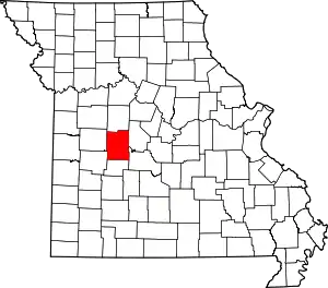 Map of Missouri highlighting Benton County | |
| Village | ||
| Townships | ||
| CDPs | ||
| Unincorporated communities | ||
| Former settlements | ||
| Footnotes | ‡This populated place also has portions in an adjacent county or counties | |
This article is issued from Wikipedia. The text is licensed under Creative Commons - Attribution - Sharealike. Additional terms may apply for the media files.