Cumaral | |
|---|---|
Municipality and town | |
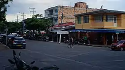 Carrera 20 in Cumaral | |
.svg.png.webp) Flag  Coat of arms | |
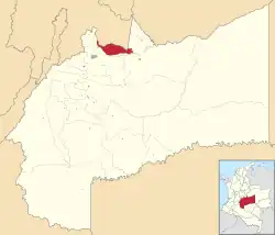 Location of the municipality and town of Cumaral in the department of Meta. | |
| Coordinates: 4°16′10″N 73°29′11″W / 4.26944°N 73.48639°W | |
| Country | Colombia |
| Department | Meta |
| Founded | July 3, 1901 |
| Named for | Cumare palm |
| Government | |
| • Alcalde | Albeiro Serna |
| Area | |
| • Total | 580 km2 (220 sq mi) |
| Elevation | 452 m (1,483 ft) |
| Population | |
| • Total | 21,397 |
| • Density | 37/km2 (96/sq mi) |
| Time zone | UTC-5 (Colombia Standard Time) |
| Website | Official Website of Cumaral |
Cumaral is a town and municipality in the Colombian department of Meta.
References
- ↑ "Censo Nacional de Población y Vivienda 2018" (in Spanish). DANE. Retrieved 25 April 2020.
- ↑ DANE Censo 2005 - Población cumaraleña
This article is issued from Wikipedia. The text is licensed under Creative Commons - Attribution - Sharealike. Additional terms may apply for the media files.