Dawes, West Virginia | |
|---|---|
 Dawes  Dawes | |
| Coordinates: 38°08′34″N 81°27′07″W / 38.14278°N 81.45194°W | |
| Country | United States |
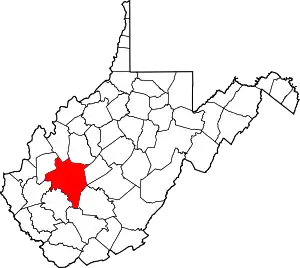
| State | West Virginia |
| County | Kanawha |
| Area | |
| • Total | 21.08 sq mi (54.6 km2) |
| • Land | 21.08 sq mi (54.6 km2) |
| • Water | 0 sq mi (0 km2) |
| Elevation | 679 ft (207 m) |
| Population | |
| • Total | 656 |
| • Density | 31.13/sq mi (12.02/km2) |
| Time zone | UTC-5 (Eastern (EST)) |
| • Summer (DST) | UTC-4 (EDT) |
| ZIP code | 25054 |
| Area code(s) | 304 & 681 |
| GNIS feature ID | 1538069[2] |
Dawes is an unincorporated community in Kanawha County, West Virginia, United States. Dawes is 5 miles (8.0 km) south of East Bank along Cabin Creek.[3] Dawes has a post office with ZIP code 25054.[4]
References
- 1 2 "Dawes, WV 25054". Retrieved June 19, 2010.
- ↑ "US Board on Geographic Names". United States Geological Survey. October 25, 2007. Retrieved January 31, 2008.
- ↑ The National Map, accessed 19 October 2016.
- ↑ ZIP Code Lookup
This article is issued from Wikipedia. The text is licensed under Creative Commons - Attribution - Sharealike. Additional terms may apply for the media files.