Espenau | |
|---|---|
 Coat of arms | |
Location of Espenau within Kassel district 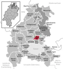 | |
 Espenau 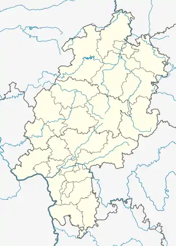 Espenau | |
| Coordinates: 51°23′35″N 9°27′32″E / 51.3930°N 9.4588°E | |
| Country | Germany |
| State | Hesse |
| Admin. region | Kassel |
| District | Kassel |
| Government | |
| • Mayor (2020–26) | Carsten Strzoda[1] |
| Area | |
| • Total | 13.59 km2 (5.25 sq mi) |
| Elevation | 266 m (873 ft) |
| Population (2022-12-31)[2] | |
| • Total | 5,266 |
| • Density | 390/km2 (1,000/sq mi) |
| Time zone | UTC+01:00 (CET) |
| • Summer (DST) | UTC+02:00 (CEST) |
| Postal codes | 34314 |
| Dialling codes | 05673 |
| Vehicle registration | KS |
| Website | www.espenau.de |
Espenau is a municipality in the district of Kassel, in Hesse, Germany. It is composed of two districts the Espenau-Hohenkirchen, and the Espenau-Mönchehof both are situated 9 kilometers north of Kassel. As of December 2019, Espenau has 5,158 inhabitants. It covers a total area of 13.59 km².
Geography
Espenau is bordered by the municipalities of Immenhausen to the north, Fuldatal to the east, Vellmar to the south, and Calden and Grebenstein to the west.
A pond at the northern edge of Hohenkirchen is the source of the Esse river. The Espe river, a tributary of the Fulda, starts in the western portion of Espenau and flows through the town, and gives the town its name.[3]
Espenau is about 6 kilometers from the rococo style Wilhelmsthal Castle.
History
Hohenkirchen's earliest mention is in a certificate dating back to 1285. In 1216, the Hardehausen Monastery built a farm in the area of Mönchehof, likely given its name in 1500 because of the two monks that operated the farm. As part of a larger series of local government reorganization in Hesse, the villages of Hohenkirchen and Mönchehof were combined into the same municipality of Espenau in October 1970.[4]
Coat of Arms
The coat of arms depicts four aspen tree leaves against red and white quandrants, a reference to the town's name of Espenau (German: Espe).[3]
Transportation
Espenau-Mönchehof has a stop on the Kassel–Warburg railway. It is connected by the Kassel RegioTram Line 1 to Kassel Hauptbahnhof.[5] It is also connected via bus to Immenhausen Vellmar, Calden, and the nearby Kassel Airport.[6]
Notable people
Bernd Herrmann (*1951)- West German athlete who primarily competed in the 400 metres.
References
- ↑ "Ergebnisse der letzten Direktwahl aller hessischen Landkreise und Gemeinden" (XLS) (in German). Hessisches Statistisches Landesamt. 5 September 2022.
- ↑ "Bevölkerung in Hessen am 31.12.2022 nach Gemeinden" (XLS) (in German). Hessisches Statistisches Landesamt. June 2023.
- 1 2 "Gemeinde Espenau - Espenau Damals". www.gemeinde-espenau.de. Retrieved 2021-01-07.
- ↑ Zusammenschluss der Gemeinden Hohenkirchen im Landkreis Hofgeismar und Mönchehof im Landkreis Kassel zu der neuen Gemeinde „Espenau“ im Landkreis Kassel vom 12. November 1970. In: Der Hessische Minister des Inneren (Hrsg.): 1970 Nr. 48, S. 2253, Punkt 2246 (Online through Hessian state parliament, German [PDF; 5,6 MB]).
- ↑ "Karten und Pläne - KVG Kassel". www.kvg.de. Retrieved 2021-01-07.
- ↑ "Gemeinde Espenau - Infos, Pläne, Termine, ÖPNV". www.gemeinde-espenau.de. Retrieved 2021-01-07.
Towns and municipalities in Kassel district | ||
|---|---|---|
Wappen des Landkreises Kessel | ||