Trendelburg | |
|---|---|
 Coat of arms | |
Location of Trendelburg within Kassel district 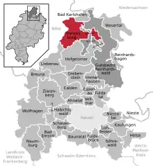 | |
 Trendelburg  Trendelburg | |
| Coordinates: 51°35′N 09°25′E / 51.583°N 9.417°E | |
| Country | Germany |
| State | Hesse |
| Admin. region | Kassel |
| District | Kassel |
| Government | |
| • Mayor (2017–23) | Martin Lange[1] |
| Area | |
| • Total | 69.35 km2 (26.78 sq mi) |
| Elevation | 130 m (430 ft) |
| Population (2022-12-31)[2] | |
| • Total | 4,867 |
| • Density | 70/km2 (180/sq mi) |
| Time zone | UTC+01:00 (CET) |
| • Summer (DST) | UTC+02:00 (CEST) |
| Postal codes | 34388 |
| Dialling codes | 05675 |
| Vehicle registration | KS |
| Website | www.trendelburg.de |
Trendelburg (German pronunciation: [ˈtʁɛndl̩ˌbʊʁk] ⓘ) is a town in the district of Kassel, in Hesse, Germany with a population of 5,282 on 30 September 2009.[3] It is situated on the river Diemel, 29 km (18 miles) north of Kassel.
The town is twinned with Pocklington, England.
Trendelburg is located on the German Timber-Frame Road.
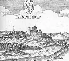
Trendelburg, 1655 (Topographia Hassiae)
References
- ↑ "Ergebnisse der letzten Direktwahl aller hessischen Landkreise und Gemeinden" (XLS) (in German). Hessisches Statistisches Landesamt. 5 September 2022.
- ↑ "Bevölkerung in Hessen am 31.12.2022 nach Gemeinden" (XLS) (in German). Hessisches Statistisches Landesamt. June 2023.
- ↑ "Bevölkerung der hessischen Gemeinden" (in German). Hessisches Statistisches Landesamt. Archived from the original on 23 May 2012. Retrieved 4 May 2010.
External links
- Official Website (in German)
Towns and municipalities in Kassel district | ||
|---|---|---|
Wappen des Landkreises Kessel | ||
This article is issued from Wikipedia. The text is licensed under Creative Commons - Attribution - Sharealike. Additional terms may apply for the media files.