| Flathead Range | |
|---|---|
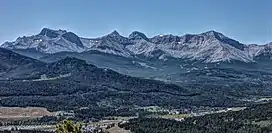 Flathead Range in the Crowsnest Pass area. Left to rightː Mount Coulthard, Andy Good Peak, Mount Parrish, Chinook Peak. | |
| Highest point | |
| Peak | Mount Ptolemy |
| Elevation | 2,815 m (9,236 ft)[1] |
| Coordinates | 49°32′56″N 114°37′52″W / 49.54889°N 114.63111°W[2] |
| Geography | |
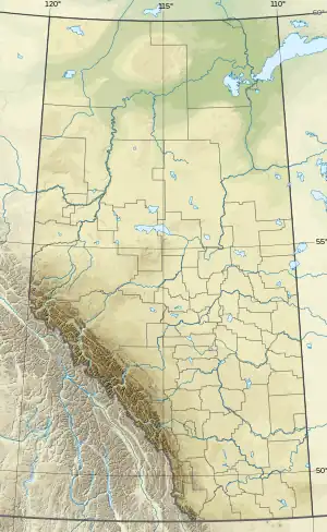 Location of Flathead Range  Flathead Range (Canada) (Canada) | |
| Country | Canada |
| Provinces | Alberta and British Columbia |
| Range coordinates | 49°26′59″N 114°35′59″W / 49.44972°N 114.59972°W[3] |
| Parent range | Crowsnest Range |
| Borders on | Castle Wildland Provincial Park |
| Geology | |
| Orogeny | Lewis Overthrust |
The Flathead Range is a mountain range of the Canadian Rockies in Alberta and British Columbia, Canada. It is located on the Continental Divide, east of Fernie, in the Kootenay Land District.[4] It stretches 27 km (17 mi) lengthwise north–south from Crowsnest Pass to North Kootenay Pass. The range's toponym was officially adopted on 30 June 1912 by the Geographic Board of Canada, and was named in association with the Flathead River.[3]
The highest peak is Mount Ptolemy, with an elevation of 2,815 m (9,236 ft).[5]
Summits
| Peak | Elevation | Prominence | Coordinates | ||
|---|---|---|---|---|---|
| m | ft | m | ft | ||
| Andy Good Peak | 8,734
style="text-align:right;" data-sort-value="7002262000000000000"|262 |
860 | 49°33′55″N 114°35′17″W / 49.56528°N 114.58806°W | ||
| Centre Mountain | 8,533
style="text-align:right;" data-sort-value="7002310000000000000"|310 |
1,020 | 49°24′46″N 114°36′27″W / 49.41278°N 114.60750°W | ||
| Chinook Peak | 8,501
style="text-align:right;" data-sort-value="7002246000000000000"|246 |
807 | 49°35′8″N 114°36′36″W / 49.58556°N 114.61000°W | ||
| Mount Coulthard | 8,678
style="text-align:right;" data-sort-value="7002255000000000000"|255 |
837 | 49°33′26″N 114°34′22″W / 49.55722°N 114.57278°W | ||
| Mount Darrah | 9,039
style="text-align:right;" data-sort-value="7002428000000000000"|428 |
1,404 | 49°28′22″N 114°35′37″W / 49.47278°N 114.59361°W | ||
| Mount McGladrey | 8,655
style="text-align:right;" data-sort-value="7002198000000000000"|198 |
650 | 49°30′36″N 114°35′14″W / 49.51000°N 114.58722°W | ||
| La Coulotte Peak | 7,999
style="text-align:right;" data-sort-value="7002285000000000000"|285 |
935 | 49°11′59″N 114°19′5″W / 49.19972°N 114.31806°W | ||
| Mount McLaren | 7,549
style="text-align:right;" data-sort-value="7002220000000000000"|220 |
720 | 49°34′59″N 114°34′5″W / 49.58306°N 114.56806°W | ||
| Mount Parrish | 8,300
style="text-align:right;" data-sort-value="7002161000000000000"|161 |
528 | 49°34′30″N 114°35′17″W / 49.57500°N 114.58806°W | ||
| Mount Pengelly | 8,484
style="text-align:right;" data-sort-value="7002226000000000000"|226 |
741 | 49°30′6″N 114°35′46″W / 49.50167°N 114.59611°W | ||
| Mount Ptolemy | 9,236
style="text-align:right;" data-sort-value="7002885000000000000"|885 |
2,904 | 49°32′56″N 114°37′52″W / 49.54889°N 114.63111°W | ||
| Sentry Mountain | 7,989
style="text-align:right;" data-sort-value="7002205000000000000"|205 |
673 | 49°36′41″N 114°38′18″W / 49.61139°N 114.63833°W | ||
See also
References
- ↑ "Topographic map of Mount Ptolemy". opentopomap.org. Retrieved 2023-08-13.
- ↑ "Mount Ptolemy". BC Geographical Names. Retrieved 2023-08-13.
- 1 2 "Flathead Range". BC Geographical Names. Retrieved 2022-09-21.
- ↑ "Flathead Range". Geographical Names Data Base. Natural Resources Canada. Retrieved 2022-09-21.
- ↑ "Flathead Range". cdnrockiesdatabases.ca. Retrieved 2022-09-21.
External links
- Flathead Range: weather forecast