Gerendás | |
|---|---|
 Coat of arms | |
 Gerendás | |
| Coordinates: 46°35′49″N 20°51′36″E / 46.597°N 20.860°E | |
| Country | |
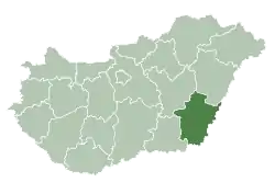
| County | Békés |
| Area | |
| • Total | 40.78 km2 (15.75 sq mi) |
| Population (2002) | |
| • Total | 1,576 |
| • Density | 39/km2 (100/sq mi) |
| Time zone | UTC+1 (CET) |
| • Summer (DST) | UTC+2 (CEST) |
| Postal code | 5925 |
| Area code | 66 |
Gerendás is a village in Békés County, in the Southern Great Plain region of south-east Hungary. The nearest city is Csorvás.[1]
It covers an area of 40.78 km2 and has a population of 1576 people (2002).
| City with county rights |
|   |
|---|---|---|
| Towns | ||
| Large villages | ||
| Villages |
| |
| Other topics |
| |
References
- ↑ Latitude.to. "GPS coordinates of Gerendás, Hungary. Latitude: 46.5970 Longitude: 20.8600". Latitude.to, maps, geolocated articles, latitude longitude coordinate conversion. Retrieved 2020-09-15.
This article is issued from Wikipedia. The text is licensed under Creative Commons - Attribution - Sharealike. Additional terms may apply for the media files.